Enumclaw gets possible funnel cloud ahead of thunderstorms
Sep 16, 2019, 4:44 PM
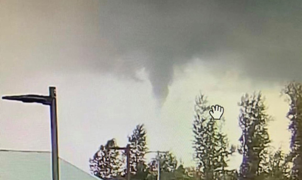
A potential funnel cloud over Enumclaw. (@frebcyndi, Twitter)
(@frebcyndi, Twitter)

What appeared to be a funnel cloud appeared in the sky over Enumclaw Monday.
Rain, wind, and thunderstorms coming to Western Washington this week
The cloud turned up just before 3 p.m. Whether or not it was actually a true funnel cloud — basically a tornado that doesn’t touch the ground — is unclear. Still, the National Weather Service hasn’t ruled out the possibility.
@NickAllardKIRO7 hey nick my daughter just sent me this picture pic.twitter.com/HTUI3JHT84
— cyndi (@frebcyndi) September 16, 2019
“It could have been a funnel cloud, but hard to determine without seeing any movement,” the NWS said on Twitter. “On the radar, cell wasn’t very strong, & bcuz[sic] the beam at that distance from the radar was at 5700 ft, could not see any definite rotation. However, we can’t rule out any shallow rotation.”
This comes as thunderstorms begin to move into Western Washington, with one lightning strike detected northwest of Enumclaw.
Even with those storms, Monday will be light compared to Tuesday. KIRO 7 meteorologist Nick Allard predicts that a wet cold front will bring in the potential for about an inch and a half of rain in the Puget Sound region. Heavier winds will also enter the area, with gusts in the 30-40 mph range.
Once the cold front leaves the Seattle area Tuesday afternoon, more isolated thunderstorms are possible.