Forgotten photos discovered from one of BC’s most devastating landslides
Jan 15, 2020, 9:04 AM


It was not too far north of the border of Washington 55 years ago this week, when an event now known as the “Hope Slide” wiped out a long section of a provincial highway in British Columbia. The highway department in BC just marked the anniversary by sharing a treasure trove of long lost images of the massive and deadly slide (pictured above).
The Hope Slide took place on the morning of Saturday January 9, 1965 on BC Highway 3, about 12 miles east of the Fraser Valley community of Hope. Hope is not too far from Harrison Hot Springs, and is where Highway 3 cuts off from Trans-Canada Highway 1 toward Manning Provincial Park and the community of Princeton, BC.
Kristen Reimer is a communications officer with the BC Ministry of Transportation and Infrastructure.
“Nobody’s forgotten about it. It’s still visible if you drive through the area,” Reimer said by phone from her office in Victoria, BC earlier this week. “BC Highway 3 was actually buried by [the slide] for almost three kilometers [or two miles] but it’s still a part of our culture and our history.”
Given the scope and scale of the slide — which the newly discovered images give some sense of — it’s no wonder it remains memorable for the Ministry of Transportation and Infrastructure more than half a century later.
“We were all overwhelmed by the sheer scale of the of the slide itself,” Reimer said. “It’s still a scar on the side of the mountain, and it’s hard not to see when you drive through the area.”
That includes a memorial plaque and viewpoint where drivers can pull off the highway and see the remnants of the slide for themselves.
Reimer says that Highway 3 dates back to the 1860s, when a surveyor named Edgar Dewdney was commissioned by the provincial government to create a route for prospectors in the gold rushes of that era.
That route came to be known as the Dewdney Trail, and it’s still a mountainous part of British Columbia. So it’s not surprising that the first sign of trouble 55 years ago was an avalanche from a 4,000-foot mountain called Johnson Peak that blocked Highway 3 around 4:00 a.m. on that eventful Saturday in 1965.
The avalanche was big enough that traffic was stopped in both directions. Two trucks and a passenger car waited on the east side of the slide, but fortunately, others chose not to wait and instead turned around.
It was a few minutes before 7:00 a.m. when an almost incomprehensible amount of rock, mud, and debris came down into the valley and over the highway, as about half of Johnson Peak let loose in one of the largest landslides in Canadian history.
The result was a massive shifting of the landscape and massive destruction of the valley, and, unfortunately, loss of human life. Kristen Reimer says it could have been a lot worse.
“We’ve heard from people who said that there was a Greyhound bus that was stopped at the avalanche, and then they decided not to wait and they turned around and they went back up the mountain towards Manning Park and towards Princeton,” Reimer said. “Anybody who was at the site who was stopped and waiting for the avalanche to be cleared was unfortunately a victim [in the] landslide.”
The quantity of material that came down onto Highway 3 is estimated to be somewhere around 47 million cubic meters, or half a mountain’s worth of rock, mud, snow, trees and other debris. The slide also completely wiped Lake Outram, and covered about two miles of roadway as deep as an unbelievable 500 feet in some places.
A search and rescue effort was launched almost immediately. By Sunday, Jan. 10, crews had recovered two bodies — the driver of a hay truck and the driver of a passenger car — but two passengers who were in that second driver’s car were never found.
Kristen Reimer says that BC Highway 3 wasn’t just some country road; it’s the southern alternative to the Trans-Canada Highway, which jags pretty far to the north at Hope. So the loss of the highway wasn’t something to be taken lightly.
“It used to be called the Southern Trans-Provincial Highway,” Reimer said. “It connected the Vancouver area to the rest of the country of Canada, [to] Alberta and all the other provinces.”
Reimer says that in the aftermath of the Hope Slide, the provincial government didn’t waste any time in working to re-open the route.
“When that highway was cut in 1965, it was a really significant closure, and so the Highways Department really had the pressure on to get that route re-established,” Reimer said.
Remarkably, in just 13 days – in an effort that calls to mind the I-5 Skagit Bridge collapse of 2013 and the Oso slide of 2014 – the BC Highways Department managed to build a new temporary road essentially over and around the slide.
“We have a lot of pride here in keeping our highways open, and I know that [for] our staffers it was a big achievement,” Reimer said. “I mean, it was a somber achievement and it was a serious time, but getting that highway open was a great thing.”
That “temporary” stretch of road, Reimer says, was full of twists and turns, which can be seen in a vintage video produced by BC Highways Department in 1966. The route was left in place until the late 1970s, when a new and less curvy realignment was constructed.
Reimer also says that the cause of the slide was never really determined. It’s thought to have likely been some combination of geology and weather, and the long-term geological deterioration of Johnson Peak.
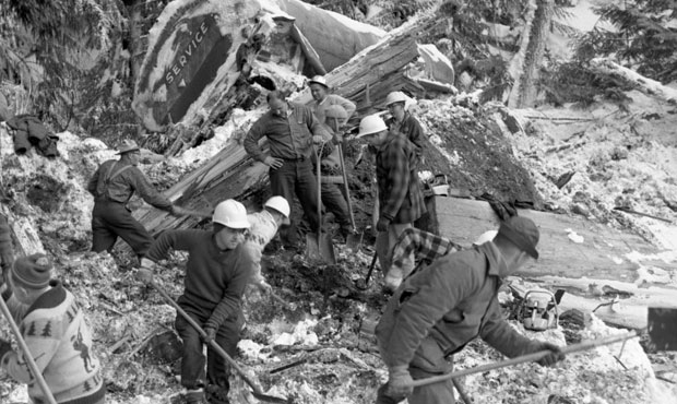
Reimer knows a lot about Highways Department history, and is always on the lookout for artifacts and archival treasures that she can use to help share this history. A few years ago, she inherited a number of boxes of materials from a previous employee. That’s where she recently discovered about 50 images of the slide, most of which have never before been made available to the public.
The images are high-quality, and appear to have been shot by a professional photographer with experience in photojournalism; there are close-ups of workers and damaged vehicles, and aerial shots of the slide area. Reimer scanned the originals, and shared dozens of them on social media.
“As far as I know, one or two of them were shared out in 1965 following the event and then they were just kind of shelved,” Reimer said. “I think it actually was a really sensitive thing. It was a really large experience – a big thing that happened to us – and I think nobody really wanted to talk about it too much until just in recent years.”
But history and the passage of time have a way of dulling the more painful aspects of a tragedy such as the Hope Slide.
“I felt like the time was right to share it out, because [it’s been] 55 years now since the event happened,” said Reimer, who will see to it that the originals are preserved at the BC Provincial Archives.