All Over The Map: Point Roberts is ‘a wild place, removed from civilization’
Aug 28, 2020, 11:05 AM
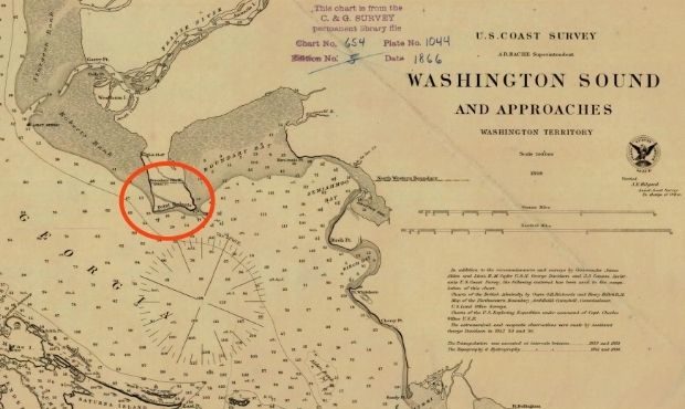
This 1866 nautical chart shows Point Roberts, American territory at the southern end of the Tsawwassen Peninsula -- a thumb of land which begins north of the international boundary, but which extends below the 49th parallel. (NOAA Archives)
(NOAA Archives)

Point Roberts is a small, yet distinctive part of Washington, west of Blaine up by the Canadian border in Whatcom County. It’s part of the United States, but isn’t actually connected by land to the Lower 48.
The remote American community is a quirk of the Treaty of 1846 that set the boundary between the United States and Canada at the 49th parallel. Geographically speaking, Point Roberts is the lower portion, roughly 2.5 miles long and the same distance wide, of the Tsawwassen Peninsula. That thumb of land begins in British Columbia and extends south below 49 degrees north latitude, creating unique circumstances – and challenges – for the Americans who live on that southern portion.
Washington Governor Jay Inslee on Aug. 21 sent a letter to Canadian Prime Minister Justin Trudeau asking for something that the 1,300 residents of Point Roberts have wanted for months – special dispensation allowing them to travel the 26 miles through British Columbia to Blaine to enter the United States and then be able to return home to Point Roberts, as they have done regularly for more than a century.
At the moment, the pandemic border closure between the U.S. and Canada has been extended until Sept. 21. Point Roberts residents, of course, are welcome anytime to travel to other parts of Washington via boat or plane, but that can be inconvenient and expensive.
The land was home to indigenous people for thousands of years, and the first European to see what’s now Point Roberts was the Spanish explorer José María Narváez in June 1791.
Narvaéz mistakenly thought the peninsula was an island, and named it “Isla de Zepeda” (sometimes spelled “Cepeda”), perhaps after Feliz de Zepeda – a contemporary naval officer who was involved in Spanish activity at Nootka Sound – according to a 20th century scholar named Henry Wagner. A year later, in 1792, Spanish explorers Galliano and Valdés figured out that the “island” was actually a peninsula, and it became “Punta de Zepeda.”
Like so many Spanish geographic names in the Pacific Northwest, Punta de Zepeda never really stuck because in 1792, Captain George Vancouver was also in the neighborhood, exploring the waterways and bestowing British-inspired names on landmarks and geographic places. On June 12, 1792, Captain Vancouver honored his friend and contemporary Captain Henry Roberts by calling the tip of the peninsula “Point Roberts.”
Henry Roberts was previously in command of Vancouver’s ship “Discovery” and had been scheduled to lead the expedition to the Northwest Coast. Were it not for the threat of war with Spain over Nootka Sound that sent Roberts elsewhere on a different mission, the biggest city in British Columbia and its largest island (and a certain fort down on the Columbia River) might today instead be named for Roberts rather than for Vancouver.
Vancouver and Roberts had sailed together on two of Captain Cook’s long voyages, including to the South Pole, and to Hawaii when Cook died at the hands of natives in 1779. Roberts was a cartographer, and drew up the major charts from those voyages for publication. This past Tuesday was the 224th anniversary of Henry Roberts’ death; Captain Roberts died Aug. 25, 1796, in Jamaica of Yellow Fever. He was 39 or 40 years old.
As for Point Roberts, it was apparently a rough and tumble place in the early years of American settlement in the late 19th century. A book about Whatcom County history published in 1926 says:
“Point Roberts ‘was a sort of ‘no man’s land,’ from its unique position, and was the scene of much lawlessness, especially smuggling. Between 1880 and 1886 it was the scene of no less than three murders.”
That same book quotes a source who wrote in June 1886:
“[F]or years [Point Roberts] has been the rendezvous of smugglers and desperados. Men too lazy to earn an honest living have squatted there, fenced fishing grounds and compelled fishermen to pay tribute … The point is a wild place, removed from civilization …”
Things apparently did start to settle down a bit around that same year of 1886 when the first schoolhouse was built at Point Roberts.
Point Roberts also played a minor role during what came to be called the Pig War – that time when the Britain and the U.S. almost came to military blows, but instead negotiated the water boundary between Washington Territory and Vancouver Island. The British, who wanted their territory to include the San Juan Islands, also wanted all of Point Roberts, too.
The matter was settled in favor of the United States in 1872. Coincidentally, that negotiation process officially began on this day – Aug. 28, 1856 – when American diplomat in London G.M. Dallas notified the Earl of Clarendon, Britain’s foreign secretary, that the Yanks were ready to sit down and hammer out a deal.
Incidentally, the name “Point Roberts” was also given to what’s now Alki Point in West Seattle in 1841 by the Wilkes Expedition, according to Edmond S. Meany, “in honor of Humphrey Roberts, armorer in one of the crews.”
Meanwhile, until the U.S. and Canada can come up with some kind of solution, or until the border opens once again, Point Roberts is, on paper at least, looking more and more like the island it was mistaken for 228 years ago.
You can hear Feliks every Wednesday and Friday morning on Seattle’s Morning News and read more from him here. If you have a story idea, please email Feliks here.