All Over The Map: Willamette Stone is the DNA of all Northwest real estate
Jul 23, 2021, 8:55 AM | Updated: 12:06 pm
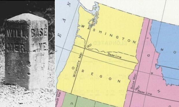
The Willamette Stone marks the point where the Willamette Meridian and Willamette Baseline cross west of Portland. (Oregon State Parks)
(Oregon State Parks)

The DNA of all private and public land ownership in Washington and Oregon — including the “treaty wars” and restrictive racist real estate covenants – can be traced back 170 years to a monument west of Portland known as the Willamette Stone.
The Willamette Stone marks the intersection of the Willamette Meridian, which runs north to south, and the Willamette Baseline, which runs east to west. These are invisible lines – the ‘x’ axis and the ‘y’ axis – of a giant invisible grid that was first laid out in 1851.
Dan Klug is the head interpretive ranger for Oregon State Parks for the area that includes the Willamette Stone Oregon Heritage Site. Klug knows more about the Willamette Meridian than just about anyone.
“It’s the basis for all surveying that was done in Oregon and Washington in the 1850s and then successive dates as well,” Klug told KIRO Radio. “And to this day, everything is based off of the Willamette Meridian and its counterpart, which is the [Willamette] Baseline. The meridian runs north and south from a point in the West Hills of Portland where they originated it, and it runs north to the Puget Sound, and south to the California border.”
It was on June 1, 1851, when a crew working for John B. Preston, Oregon’s first surveyor general, hammered in a wooden stake to mark the origin point for the Willamette Meridian and the Willamette Baseline – as directed by the Government Land Office (GLO), a precursor to the Bureau of Land Management (BLM). Preston made it official a few days later on June 4, 1851.
Decades later, a more permanent stone monument was installed July 25, 1885 – 136 years ago this Sunday – but that stone was vandalized multiple times, and now only the base remains at the heritage site, along with an official benchmark and a series of interpretive panels. East of the Willamette Stone in what’s now urban Portland, a series of 19th century monuments marking the baseline also can be spotted – if you know where to look.
Before the federal government created the Willamette Meridian, Klug says an earlier and somewhat simpler system was instituted by settlers – those same impatient Oregonians who had created their own provisional government at Champoeg.
“Boundaries and claims for the land were set up, but it was more like what I call a ‘hatchet claim,’” Klug said, “where one guy said, ‘As far as I can see this direction and this direction and that direction, that’s my land.’”
“And [then] you walked around with a hatchet and marked trees,” to indicate boundaries, Klug said. “So they needed something that was more evidential.”
They also needed something that would be easy for settlers and officials to work with as claims were filed in the short term and in the years and decades ahead. So, the baseline was intentionally set to fall south of the Columbia River, and the meridian stretched as far north as Puget Sound. In 1851, what’s now Washington was part of Oregon Territory, and there were far fewer settlers around Puget Sound than there were in the Willamette Valley.
The name “Willamette” comes from an Indigenous word of unknown meaning, and has been spelled many different ways over the years. The river and river valley are both called Willamette, though Lewis and Clark called it “Multnomah” in 1805, after nearby Indigenous people; and Lt. William Broughton of Vancouver’s expedition, who explored the Columbia River in 1792, named it “Manning,” likely after Boatswain’s Mate Samuel Manning.
The Willamette Meridian and the Willamette Baseline are part of something called the rectangular land surveying system, which dates to 1785 and the Articles of Confederation, and which presciently (and, perhaps, also aspirationally) was envisioned as stretching, ultimately, across the entire continent. It’s called the Public Land Survey System – or “PLSS” – nowadays, and it applies in much of the United States, excluding Texas, the 13 original colonies, and Hawaii, where they have their own separate but similar systems.
Oregon Territory had become part of the United States in 1848, and settlers were claiming land under the Donation Land Act of 1850, so there had to be a universally recognized system to keep track of who had claimed what. Of course, the notion of land ownership was totally foreign to the Indigenous peoples who had been here for millennia, and it was confusion and struggles over land ownership – and “extinguishing title” to land, which led to the deadly treaty wars – as well as the forced relocation to reservations, the redrawing of reservation boundaries to favor settlers, and other government policies that eroded traditional ways of life for the region’s original inhabitants.
Meridians and baselines also form the backbone of the system of townships, the official name for the squares in the grid formed by the north-south and east-west lines. A township is a 6-mile by 6-mile square, comprising a total of 36 one-square mile areas called sections; there are 640 acres in a section. This will not be on the midterm.
There are a total of 37 of these meridians in the United States; Willamette was the first to be laid out west of the Rockies, and, depending on different sources, it was either the 15th or 17th overall. Other meridian/baseline combos nearby include the Boise in Idaho and Humboldt in Northern California. This might be on the midterm.
For any real estate parcel in Washington or Oregon, the legal description probably includes the name of the person or entity who created the subdivision, for laying out streets and subdividing land for individual lots suitable for homes or businesses — and, in some cases, also containing racist covenants. But also included on the deed is language – directly related to the Willamette Meridian – describing which square in the grid that contains the particular piece of land.
For example, for the building where KIRO Radio is housed along Eastlake Avenue in Seattle, this part of the legal description would read as “Township 25 North, Range 4 East of the Willamette Meridian.” In legal paperwork, according to veteran Northwest surveyor Bob Winters of Seattle firm Chadwick & Winters, it’s often just abbreviated as “W.M.”
Winters also told KIRO Radio that the Willamette Meridian is still something surveyors working in the field in 2021 interact with every day; it may be esoteric, but it’s not some piece of distant and forgotten history, only gathering dust. This will be on the midterm.
You can hear Feliks every Wednesday and Friday morning on Seattle’s Morning News, read more from him here, and subscribe to The Resident Historian Podcast here. If you have a story idea, please email Feliks here.