Haze over Western Washington being compared to cloud cover
Aug 2, 2017, 9:06 AM | Updated: 9:09 am
(KIRO 7)
(KIRO 7)

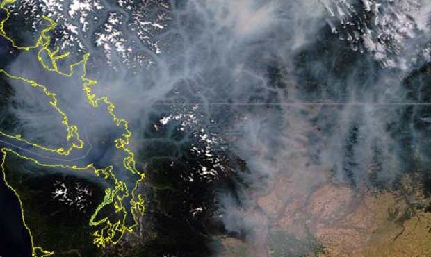
If residents of British Columbia were wondering where the smoke from local wildfires went, they needn’t look farther than Western Washington.
The haze we are seeing in the air around Puget Sound and along the I-5 corridor is directly linked to the more than 100 wildfires burning in the Canadian province. The fires have forced an extension of a state of emergency in B.C.
The National Weather Service reports the smoke is so thick it is similar to cloud cover.
KIRO 7 Meteorologist Nick Allard says the smoke may lower temperatures in the region — slightly.
Air quality is quickly decreasing. Washington’s Air Monitoring Network map shows many of the cities along I-5 are either experiencing moderate quality or worse. There is a warning around Seattle that the air quality is unhealthy for sensitive groups. In Tacoma, the air quality Wednesday morning was considered unhealthy.
The haze is also causing minor flight delays in and out of Sea-Tac Airport. According to the airport’s Twitter account, there are no major delays, but travelers should check their flight status.
University of Washington Climatologist Cliff Mass explains why the smoke moved south:
Because the developing heat wave is producing lower pressure (thermal trough) over Oregon, producing a north-south pressure difference (with lower pressure to the south). This supported northerly flow.
In B.C., where the smoke is originating from, it appears some people are beginning to enjoy clearer skies.
Nice bike ride in to work this morning, the smoke has definitely cleared a fair bit! #Kamloops #BCWildfires pic.twitter.com/XzBJeBfJKD
— Doug Herbert (@DHerbertCBC) August 2, 2017
Meanwhile, we’ll just be stuck inside.