February says goodbye with another round of snow in Puget Sound region
Feb 27, 2019, 4:57 PM | Updated: Feb 28, 2019, 6:22 am
(National Weather Service)
(National Weather Service)
Tired of snow yet? Well, Mother Nature isn’t. More is expected to fall in the Puget Sound region early Thursday morning after some light snow Wednesday night.
RELATED: Should Seattle rethink its plans for snow plows?
RELATED: How the City of Seattle responds to snow
Though, accumulation isn’t likely, with many areas expected to see less than an inch. Flurries will give way to partly sunny skies as the day continues. The frigid 29 degree morning (in Seattle) will also warm up to highs in the mid 40s.
Drying out! pic.twitter.com/7hiFHJHUpr
— Nick Allard (@NickAllardKIRO7) February 28, 2019
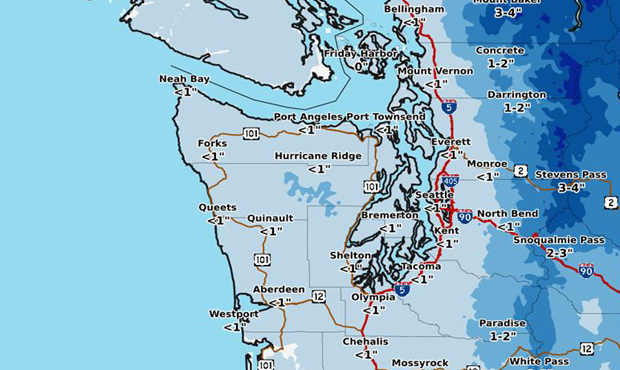
According to the National Weather Service, light snow and flurries were in the forecast starting Wednesday evening. Accumulations ranged depending on where you are — 1 to 2 inches were expected near the Cascades, and 2 to 4 inches were expected in the Cascades themselves. In Seattle, Everett, Kent, Tacoma, and Olympia, an inch or less of snow was expected, with any accumulation likely limited to grass and not roads.
Light snow showers over Puget Sound this evening will continue to push off to the northeast tonight. A few spots might get up to an inch but most areas probably will get little if any accumulation. #wawx pic.twitter.com/WugodbSoAA
— NWS Seattle (@NWSSeattle) February 28, 2019
The National Weather Service notes that along with the blast of snow this February, the region had other notable records. This winter was .2 degrees colder than the average for the past 30 winters — the third coldest February on record.
With meteorological winter ending today, Seattle’s average temperature over the past 3 months was 41.9. That’s just 0.2 degrees below the average of the past 30 winters. Impressive when you consider we had the 3rd coldest February on record. Indeed, it was a winter of extremes.
— NWS Seattle (@NWSSeattle) February 28, 2019
Follow @http://twitter.com/Mynorthwest