Freezing temperatures set in for ‘next several days’ in Puget Sound region
Oct 29, 2019, 8:17 AM | Updated: 11:32 pm
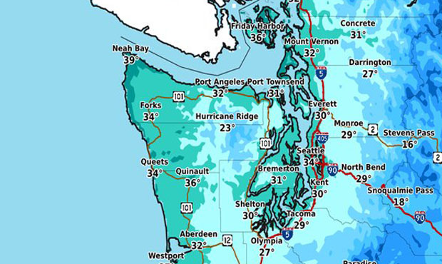
We could see record lows in Western Washington before the week is out. (NWS Seattle)
(NWS Seattle)

Things are getting cold in Western Washington, with wind chill pushing freezing temperatures down near record lows in parts of the region.
‘Dice may be loaded’ for November snow in Seattle
It is 8PM and temps around W WA are in the 30s to mid 40s. #Shelton is already at 29°!
Who wants cocoa?! ☕️#WAwx #cold #chilly pic.twitter.com/9ByRcgCQgm— NWS Seattle (@NWSSeattle) October 30, 2019
On Monday, temperatures dropped into the 20s and 30s across the Puget Sound region in the early morning hours. Seattle’s low of 34 degrees to start the week was a full 10 degrees below normal for the month.
That continued Tuesday, with wind chill adding a new facet to the recent cold snap. While actual temperatures in most parts of the region sat in the upper 30s, high winds had it feeling more like the upper 20s/low 30s, especially near Orting, Graham, and Fort Lewis. Olympia measured 31 degrees. Shelton was 29.
“It’s COLD no matter how you slice it,” said Seattle Weather Blog’s Justin Shaw on Twitter.
High winds have persisted through Tuesday afternoon, ranging between 15 and 45 miles per hour. Seattle has seen winds between 20 and 25 miles per hour, with the highest speeds in the immediate area set to land in North Bend (40 to 45 miles per hour).
‘Arctic express’ arrives in Western Washington
This all comes without a drop of rain in the forecast, despite consecutive days with record lows at the National Weather Service’s Seattle office.
A record low was set for the second day in a row at the NWS office in Seattle on Monday. The low of 34 degrees broke the old record of 35 set in 2001. More record lows could be set across the area the next few days as even colder morning lows are expected. #wxwa
— NWS Seattle (@NWSSeattle) October 29, 2019
The NWS expects near or below freezing low temperatures to set in for “the next several days” across Western Washington. This marks the coldest stretch for most locations since March 12, the last day of the epic 40-day stretch of cold (and sometimes snowy) weather early in 2019.
The coldest temperatures this week will likely set in on Wednesday morning. The next rainy day isn’t expected until next Monday.
All this could be the precursor to what UW climate scientist Cliff Mass predicts will be a “very active winter” for Western Washington, spurred by an unusually early “Arctic express.”
KIRO 7 staff contributed to this report