Rain tapering off, but standing water remains across Western Washington
Dec 20, 2019, 7:01 AM | Updated: Dec 21, 2019, 1:45 pm
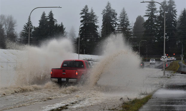
(Snohomish County DEM via Twitter)
(Snohomish County DEM via Twitter)

Forecasters say the ‘atmospheric river’ that has soaked Western Washington will begin to shift south and into the Cascade mountains on Saturday. Showery conditions coming in off the coast will feel dry in comparison to the past 36 hours.
Photos of urban flooding, downed trees
In the past 48 hours, the National Weather Service reported 3- 5 inches of rain fell in the Everett-Seattle-Tacoma region. Some areas in the foothills got 6 inches. Over 9 inches of rain fell at Crystal Mountain. Check here for a full list of totals.
More of this blue phenomena spotted on the Olympic Peninsula this afternoon. Apparently, it's caused by the scattering of light by particles in the atmosphere. Some of you may need some 🕶️ if you can still remember where you left them. #wawx pic.twitter.com/FhBMSAF7JA
— NWS Seattle (@NWSSeattle) December 21, 2019
The persistent rain resulted in several road closures across the region. Underpasses, parking lots, and roads along rivers and creeks were under several feet of water.
In Bellevue, one driver’s car was submerged so deep in flooded water, that they were forced to swim to safety.
A landslide near the Stillwater Store milepost 8 brought trees and power lines down. A fallen tree blocked eastbound I-90 at Sunset for a brief period during the Friday afternoon commute.
Flood Warnings remain in effect along several regional rivers. Check here for the full list and updates.
The National Weather Service posted a view of the ‘atmospheric river’ aimed at the Northwest.
Been out of town? Under a rock? Let's review. It started raining in Seattle at roughly noon on Thursday and there's been measurable rain every hour since. But that streak is about to end. #wawx pic.twitter.com/JzTHTQWKLi
— NWS Seattle (@NWSSeattle) December 21, 2019