Historic line through the woods separates Washington from Canada
Jun 15, 2023, 7:38 AM | Updated: 10:05 am

Editor’s Note: This story was originally published Jan. 27, 2017
On June 15, 1846, the United States and Great Britain formally ended a decades-long joint occupation of Indigenous territory, which was then known as the Oregon Country – comprising much of present-day Washington, Oregon, Idaho, and British Columbia.
The border as we know it along the 49th parallel became a reality that day, at least on paper. But it took years for the actual boundary to become real for the people living on either side of it, and work quietly continues to this day to keep the otherwise invisible line tangible and concrete.
Just about anyone who lives in Western Washington is familiar with the Peace Arch in Blaine and the adjacent border crossing into Canada. With a passport or enhanced driver’s license in hand, we’ve all braved the long lines and enigmatic questions of Canadian customs officials in order to make a quick trip to Vancouver. A killer exchange rate and a hankering for poutine are just too hard to resist.
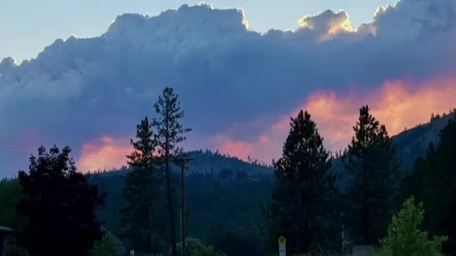
But what about east of there, through the farmlands and foothills, up into the Cascades and beyond into Eastern Washington? How is that area different from the Mexican border? And why isn’t anybody talking about building a wall in Whatcom County?
All across the forested and often mountainous northern border of Washington, from Point Roberts to Pend Oreille, there’s no wall or fence, and no plans to build either.
But there is a clearly marked line. And it’s all because of an organization called the International Boundary Commission, a joint effort of Canada and the United States with roots that go as far back as the 18th century.
J.T. Moore has been a professional surveyor for more than 25 years. He’s the “Deputy Commissioner for the United States Section” of something called the International Boundary Commission. Moore works from an office in Washington, D.C., and a handful of one-person field offices from Maine to Montana.
“We are mandated by treaty to maintain an effective boundary between the United States and Canada,” Moore said. “That’s our mission statement, basically. It goes all the way back to the 1700s and the War of Independence. We separated from Great Britain, so that was the original root of the Boundary Commission.”
Related: Vancouver Island’s forgotten colonial history
Moore’s boss is a presidential appointee named Kyle K. Hipsley, who reports to the Secretary of State. Hipsley was appointed by President Obama and, with last week’s transfer of power, might be replaced by a Trump appointee.
Meanwhile, Moore’s job, along with his staff of seven, is to maintain the boundary –
the physical line between Canada and the U.S. They’re not armed, and they’re not the Border Patrol, but their work, a distinctive combination of surveying, brush clearing, regulatory land use enforcement and diplomacy, is perhaps just as important.
“Everybody takes that line on the map for granted, but it’s actually a well taken care of, well-marked line that just doesn’t appear on a map, but it’s actually a physically marked, maintained line,” Moore said.
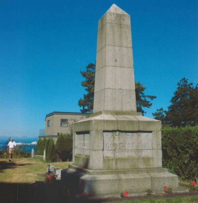
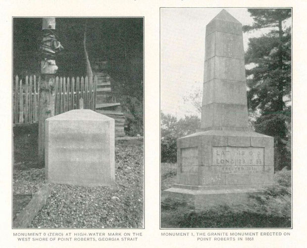
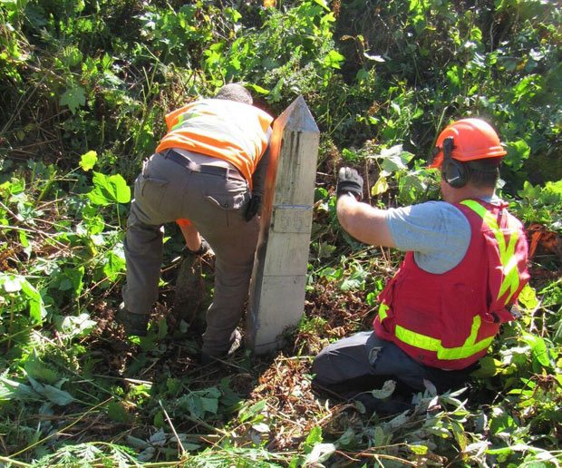
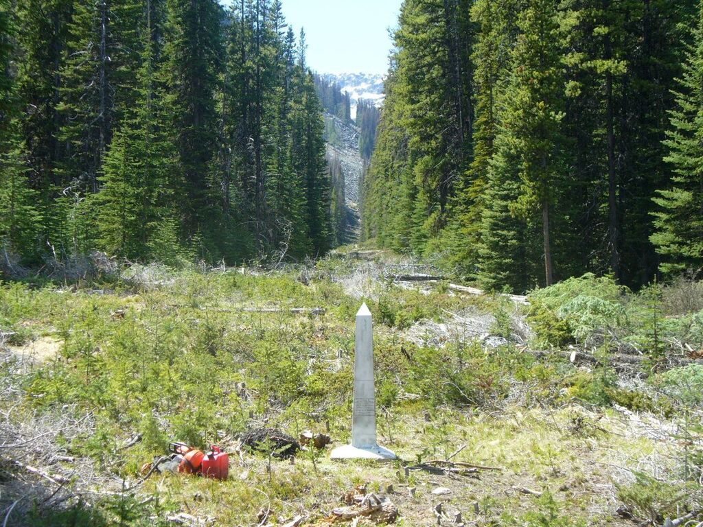
Moore says there are “monuments” every mile or so along the boundary, from Point Roberts in extreme northwest Washington all the way across the northern boundary of the United States. Here in the Pacific Northwest, the monuments are mostly 5-foot-tall metal obelisks set in stone or concrete.
Offshore, the International Boundary Commission is also responsible for marking the U.S.-Canada boundary in the waters west of Point Roberts, through Haro Strait and the Strait of Juan de Fuca.
“The boundaries that run through Juan de Fuca and all that stuff are out in the middle of the water,” Moore said. “We call those turning points [where the boundary lines shift], which are basically just a mathematical position, [and] there are monuments on either shore that makeup mathematically where that [turning] point is.”
The Treaty of 1846 between the U.S. and Great Britain set the boundary at the 49th parallel and settled once and for all (except in the San Juan Islands) which country would possess which part of the old Oregon Country.
In addition to the monuments, an area 10 feet wide is kept clear of vegetation on both sides of the boundary – half in the U.S., and half in Canada. This 20-foot wide space is known as the “boundary vista” and its role is to help with the border enforcement work of the Border Patrol and also to make it clear to anyone who stumbles across it that he or she has reached the international boundary.
“Anywhere there are wooded lands, it’s basically a right-of-way, for lack of better terminology. It’s maintained as really part of the monumentation, because it’s there for people to realize that they’re walking up onto something special, that there’s something special about that area,” Moore said. “There’s no construction allowed without consent of the Boundary Commission within 10 feet [on] either side of that line.”
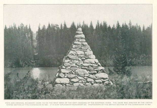
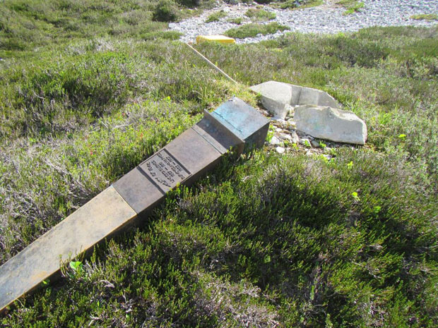
The International Boundary Commission was officially created in 1908, but the survey work to mark the boundary goes back to the mid-19th century, soon after the U.S. and Great Britain signed the Treaty of 1846. Those original 19th-century surveyors marked the boundary way back then with piles of rocks called cairns, and those cairns stood, in some cases, for more than 50 years. Moore says that nowadays, the cairns are all long gone.
Moore says that in addition to the cairns being well-made, the original surveying also appears to be the work of skilled craftsmen.
“The boundary is made up from monument to monument. It was all classically done by observing stars and dragging chains across the continent. It’s amazing how accurate those guys were,” Moore said.
“I can go out there with my GPS today and pretty much match what I’m seeing on the ground out there and what’s being reported,” he said. “It’s amazing.”
Beginning in 1908, the International Boundary Commission went through and re-surveyed the 19th-century line and replaced the old cairns with cast-iron monuments. Though many have been replaced, some of the monuments still in place along the Washington-Canada border are now more than 100 years old.
Moore says that while many of these original monuments are still doing their job, others have, well, succumbed to the elements and to other, shall we say, threats.
“You’ll [sometimes] come across one that’s clearly an original,” Moore said. “Our new ones are stainless steel because the other ones, people like to shoot them, shoot at them, put bullet holes in them.”
When that happens, Moore says, “They fill up with water, they crack, they freeze, they crack, they bust apart,” and they have to be replaced.
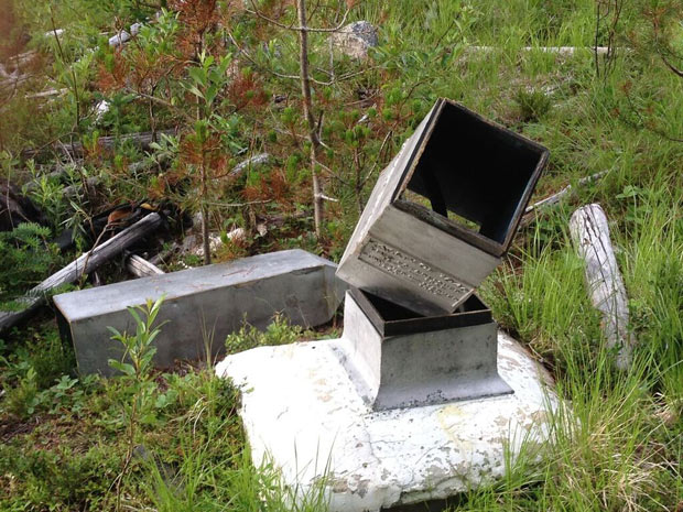
Daniel Fortin is based in Ottawa, Ontario. He’s the manager of the Canadian Section of the International Boundary Commission. He says that when the old damaged monuments are replaced, they don’t get thrown away or put in a museum. They get put right back to work, if in a somewhat different form.
“We bury [the broken pieces] around the area [of the new monument] to leave more evidence of the line,” Fortin said. “It’s really good survey practice to leave as much evidence as we can about the location of the boundary.”
Work crews that do the maintenance and who clear brush from the vista inspect each monument along more than 5,000 miles of the U.S.-Canadian border (including Alaska) at least once every 15 years. Their work isn’t much different than it was more than 150 years ago.
“Most of the boundary is inaccessible by road in most places, so it’s all still hand cut, hand cleared, [with] chainsaws, [and] hand tools – nothing’s really changed,” Moore said. “As far as technology goes, over the course of the commission, really the only thing technology-wise [that’s changed] is GPS to help us mark it, and chainsaws to help us clear it.”
As the crews work to keep the vista clear, Moore says, they often have to deal with the weather and steep terrain, and, sometimes, even dangerous creatures.
“It can be anything from bears to bugs,” Moore said, chuckling, “or the occasional unhappy landowner.”
There was an infamous court case a decade ago in Blaine, Wash., where a landowner built a retaining wall in their backyard that happened to also be within the 10-foot vista. The Boundary Commission told them they had to remove it. The landowner sued and ultimately prevailed. During the dispute, President Bush fired then-commissioner Dennis Schornack and appointed a replacement, though Schornack refused to step down until he was removed by a judge. Public radio show This American Life produced a long story about the conflict back in 2008.
For Moore, you get the sense that the lawsuit is still a touchy subject he doesn’t much want to talk about. And the same goes for questions about the potential impact of recent political changes here in the U.S.
“We operate specifically under the guidance of treaties of 1908 and 1925,” Moore said in response to a question about the role of politics in the work. “[The] 1908 [treaty] created basically the Boundary Commission as we are today, [the] 1925 [treaty] made us a permanent organization.”
Daniel Fortin of the Canadian Section, like Moore, was also trained as a professional surveyor. And like Moore, he also has a clear sense of the unique agency’s place, regardless of legal actions or whatever changes in elected leadership may happen to take place in the United States or Canada.
“The Boundary Commission is really arm’s length from government. We are a ‘surveyor’s shop,’ if I can use that expression,” Fortin said. “Our job is to maintain the line, period. That’s all we do. We make sure that the line is well-marked and that everybody knows where it is.”
You can hear Feliks every Wednesday and Friday morning on Seattle’s Morning News with Dave Ross and Colleen O’Brien, read more from him here, and subscribe to The Resident Historian Podcast here. If you have a story idea, please email Feliks here.