Thunder possible Tuesday as strong storm tapers off
Nov 25, 2018, 10:18 PM | Updated: Nov 27, 2018, 8:04 am
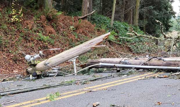
Wind blew this power pole over a car near Anacortes Monday. (KIRO 7)
(KIRO 7)
Western Washington is recovering from a strong weather system that moved through the region Monday. But the storm isn’t over quite yet with some more rain Tuesday and maybe a little thunder.
“With some modest instability in the atmosphere Tuesday, a few of the showers could have a clap of thunder, too,” KIRO 7 Meteorologist Nick Allard said. “It will be mild Tuesday with highs in the mid 50s.”
Cities that could see storm activity are Seattle, Everett, Tacoma, Bellevue, Olympia, Bremerton, and Centralia.
Allard says that the storm system was “the first big wind storm of the season.”
“We’ll keep some showers in the forecast for Wednesday and Thursday, but plenty of drier times too,” he said. “More rain comes around on Friday with mountain snow.”
Flooding
About 7.5 inches of rain fell on the Olympics and and up to 5.5 inches fell on the North Cascades within 24 hours. Sea-Tac, Quillayute, and Hoquiam broke their respective daily records for rainfall on Nov. 26, according to the weather service. Another inch of rain is expected to fall over Tuesday.
How much rain fell over the past 36 hours? Take a look! #wawx pic.twitter.com/0tIFA19nAZ
— NWS Seattle (@NWSSeattle) November 27, 2018
That adds up to river flooding. Two rivers are flooding as of Tuesday morning are the Skokomish and the Nooksack. The Skagit River is expected to hit flood stage near Concrete later in the day.
Flood watches are in place for Grays Harbor, Jefferson, Whatcom, Clallam, and Skagit counties through Tuesday evening.
“For the Nooksack River, the main area that could see some problems are around Lynden,” said Dana Felton with the National Weather Service in Seattle. “We’ve got a flood warning out for the south fork of the Nooksack as well as for Cedarville. The upper reaches of the Skagit River right now — the flooding problems will be around Concrete.”
“The two rivers we are watching right now are the Bogachiel on the coast, and the Stillaguamish in Arlington,” he said. “Right now both are below flood stage, but are rising.”
The heavy rain has mostly come to an end, but there is more rain on the horizon. Felton said that flood concerns will continue into Wednesday.
The NWS also reports that tides are expected to be about a foot higher than expected, leading to “minor tidal overflow” around San Juan, western Whatcom, western Skagit, Island and northeastern Jefferson counties.
Astronomical high tide combined with the effects of low atmospheric pressure will cause minor coastal flooding this AM on the shoreline of San Juan, Island, Whatcom, & Skagit Counties. For observed and forecast tide information, please visit https://t.co/0RXWKN6Y4o. #wawx pic.twitter.com/1e8EgwjIi6
— NWS Seattle (@NWSSeattle) November 27, 2018
Heavy winds
I spoke with the driver of this car, who tells us a power pole fell on her vehicle in the wind this morning near Anacortes. We’re covering the winds increasing in parts of the region on KIRO 7 News at 5. pic.twitter.com/FKJ4qMDlYk
— Graham Johnson (@GrahamKIRO7) November 26, 2018
A High Wind Warning was in effect until 4 a.m. Tuesday for areas around Bellingham and the San Juan Islands. By 6 a.m., the National Weather Service noted high winds around Whidbey Island.
There were also high wind warnings for the coast, Admiralty Inlet, and North Interior until early Tuesday. There were sustained winds with around 25-40 mph with gusts in the 50-60 mph range.
Winds are picking up in some places, especially on Whidbey Island where winds were gusting to 41 mph @ 6 AM. This is the 1st windstorm of the season, so there will be greater impacts (downed limbs/trees). Be prepared for power outages! #wawx pic.twitter.com/tQhfceltlt
— NWS Seattle (@NWSSeattle) November 26, 2018
Ferry routes affected by storm
The storm affected ferry routes early Monday morning. It caused cancellations throughout the day.
“It’s really rare for us to have to cancel any service in Central Puget Sound, but the outlying ferry routes, like Port Townsend Coupeville, we’ve already canceled one round trip sailing due to gale force winds,” said Ian Sterling with Washington State Ferries. “It’s blowing 50-60 mph out there and you got high seas …. other places to keep an eye on would be the San Juan Islands today.”
“Mother Nature is the boss out there and we allow our captains … to make the call whether it’s safe to go across the water or not,” he said. “We’ve got the safest ferry system on the planet and we want to keep it that way.”
Sterling also said that even if the ferries do make a run, they may not fully load boats in case of large waves coming onto the deck.
KIRO 7 contributed to this report.
Follow @http://twitter.com/Mynorthwest