Worst is over: Heavy rain ends, only light showers ahead
Dec 11, 2025, 5:59 PM | Updated: 6:15 pm
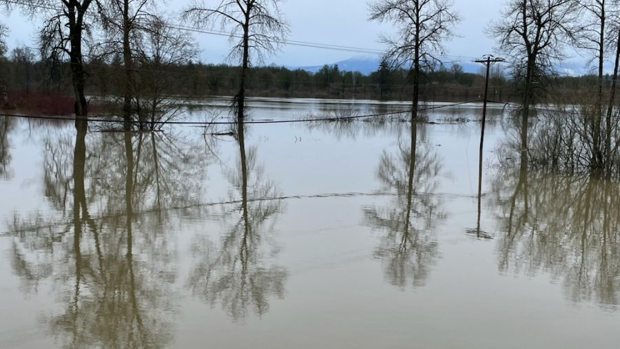
A photo of the flooding between Monroe and Duvall. (Photo courtesy of David via KIRO Newsradio text line)
(Photo courtesy of David via KIRO Newsradio text line)
The good news is that the worst of the heavy rainfall is over. Now is the time for all that moisture that has fallen, particularly in the mountains, to work its way downstream.
Nearly every river from the Canadian border to the Columbia River is or has been well over its banks. The shorter rivers, like those out of the Olympic Mountains or like the Carbon River in Pierce County, should crest and begin to recede by tonight.
Longer rivers like the Skagit, Snohomish, and Chehalis will take more time for the runoff to move downstream, meaning flood crests on Friday and even into Saturday.
RELATED STORIES


Are the current floods a historic event?
Some feel this atmospheric river/heavy rainfall event is one for the history books. For perspective, there have been similar flood events earlier this century, let alone over history going back into the 1800s.
For instance, the January 2009 flood was a similar widespread flood. Some Cascade Mountain locations had more than 30 inches of rain in just three days, resulting in significant, record-breaking flooding.
That event also resulted in adverse impacts to the Howard Hanson Dam on the Green River, resulting in the project being unable to hold back future heavy rainfall runoff events until the weakened flood protection dam was reinforced. Until then, many downstream residents had serious concerns about any potential flooding.
Another recent significant event was the flooding in early December 2007. A few locations in southwest Washington’s Willapa Hills had more than 20 inches of rain in just 24 hours, resulting in what some would call a flash flood on the Chehalis River. The U.S. Geological Survey described that flood as a 500-year flood. Interstate-5, along with many other roadways, businesses, and neighborhoods, was underwater for days.
Yet another widespread flood that was quite similar to the current atmospheric river event happened in November 2006. At that time, there was essentially no mountain snowpack. The heavy rainfall simply ran off into rivers and streams. Rainfall amounts in the Cascades were in excess of 25 inches, resulting in similar flooding that is being experienced this week.
This week’s river flooding is expected to eclipse a few of the records set earlier this century during those big flood events. The Skagit River at Mt. Vernon is likely to crest at a new record, as well as the Snohomish River in Snohomish.
Precautions continue
More than 100,000 people have been asked to evacuate low-lying flood areas in western Washington. Be sure to take all necessary actions that local authorities request, including avoiding closed roadways covered by high water or landslides. These precautions are all about the safety of life.
Remember – turn around, don’t drown. Driving on water-covered roadways is the leading cause of flood-related fatalities.
Some good news!
The source of subtropical rain has come to an end. More rain is in the forecast, but at this point, it is more typical light rain and not expected to spawn additional flooding.
In addition, after such a dry year, the region needed the rain. Thirsty area reservoirs are recovering thanks to the recent rainfall, including the upper Yakima River lakes, and Ross Lake on the Skagit River.
Those wanting snow in the mountains have been frustrated by the high snow levels with this atmospheric river event. But there is hope on the horizon. Snow levels are expected to remain elevated through this weekend, generally above 6,000 feet. An upcoming weather pattern change is forecast to drop snow levels closer to around 2,500 feet by the middle of next week. Time to wax those boards.
One more ongoing concern
The threat of more landslides will likely linger through the coming weekend. Gardeners have shared that deep down, soil is still relatively dry. Yet, the recent heavy rainfall has moistened the upper soil layers, creating heavy soils on top of lighter soils on steeper slopes and resulting in some landslides. These unstable soil conditions will remain heading into the weekend. Be wary of the potential of additional landslides.
Ted Buehner is the KIRO Newsradio meteorologist. Follow him on X and Bluesky. Read more of his stories here.