Lowland snow expected late Sunday and Monday
Dec 2, 2016, 6:38 AM | Updated: 8:59 pm

We could see snow in the lowlands Sunday and Monday. (AP)
(AP)
By KIRO 7 Chief Meteorologist Morgan Palmer
While this won’t be a “snowmaggedon,” most of us in the lowlands should expect some snow to fall, possibly as early as late Sunday in some locations.
However, Monday is the day in which most of us will see some snow. Details of amounts by location will come into better focus over the weekend, but the data Friday indicate that most of us can expect some snow in a range from just a dusting to a couple of inches.
Cold air plunging into place, but it’s the moisture that matters
The cold air arrives late on Sunday and while not frigid west of the Cascades, it will bring low temperatures as well as some daytime high temperatures down to the 30s for Monday through possibly Wednesday.
As far as precipitation goes, a system moves down along the British Columbia coast to begin Sunday with lowland rain and mountain snow. The bulk of this moisture will have moved through the region and we’ll be drying the atmosphere as the polar airmass invades the region late in the day. For the Seahawks game Sunday night, we could get a few light showers but temperatures will be falling from the lower 40s into the 30s.
Related: Seattle sets another weather record in November
The gradient, or the suddenness of the shift from a warmer, Pacific airmass to a colder, polar airmass will be rather stark. Snow levels (the elevation at which one finds mainly rain below and snow above) could plunge from 1,500 to 2,000 feet in the morning Sunday to below 500 feet by sunset Sunday evening.
Again, data points to moisture becoming quite limited by the time the snow level gets to 500 feet and below as we head into Sunday night. However, there could be a few light snow showers on the higher hills of the lowlands mainly after dark Sunday.
If this were to happen, it might whiten up grassy surfaces, but right now it appears pavement and roadways will likely be too warm for any significant accumulation.
Watching for lowland snow Monday morning
By Monday morning, it will likely be cold enough for snow down to near sea level, so we’ll be watching all lowland locations.
The wild card is still the moisture!
A follow-up disturbance moving in from the northwest Sunday night will be key to lowland snow potential Monday morning.
Forecast models are in general agreement that it will track (and bring it’s associated moisture) close enough to Western Washington to possibly fire up some snow showers in the pre-dawn hours of Monday lasting possibly as late as noon.
This is BY NO MEANS a certainty, but now that we’re getting the timing nailed down a bit better, we can watch for further details as they emerge.
How much snow will we get?
Sorry, there is just no way to know exact details at this point!
It remains possible that the Monday disturbance could go too far south, taking it’s moisture away from us and leaving us with flurries, or nothing at all.
The word I will use to describe possible snow accumulation on Monday is “light.”
And I will note there is absolutely nothing in the data I’m seeing that points to a “dump” of snow on Sunday night or Monday giving us any type of a major, crippling snow event. The moisture just simply does not look to be enough.
Plus, this disturbance that could bring the moisture for lowland snow will be a fast-mover, meaning that the atmosphere dries out quickly by Monday afternoon and evening.
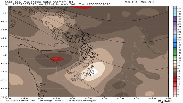
Tuesday will absolutely be cold enough for snow, sure, but it will be far too dry. As the brown colors on the image above indicates, the atmosphere will be bone dry with lows in the 20s and highs perhaps in the low to mid 30s.
Get ready to bundle up!
Wintry weather later next week as well
Long-range signs point to the grip of the cold air weakening by Wednesday or Thursday as a moist, Pacific airmass moves in.
As the cold air is scoured out by the warmer airmass in patterns similar to that, snow occasionally falls before it turns to all rain in the lowlands.
But will the cold airmass “modify” — or warm naturally — before the moisture returns, just bringing cold rain?
These are all details that will come into better view over the weekend and into early next week. But I did want to mention that even if snow is minimal or misses us altogether as the cold air arrives, we will have to watch again when the cold air leaves Wednesday or Thursday!
Fun times, indeed.
Check for school closings during winter storms