Rain tapers off Wednesday, flood warning persists for Skokomish River
Jan 5, 2021, 7:22 AM | Updated: Jan 6, 2021, 2:56 pm
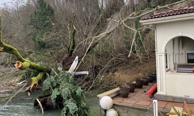
A landslide in Poulsbo forced families to evacuate. (Poulsbo Fire)
(Poulsbo Fire)
Just as forecasters predicted, a dry spell on Tuesday didn’t last long before the rain returned, but it’s now tapered off with partly sunny forecasts for Thursday.
The National Weather Service said that 2021 is the second wettest start to a year on record for Seattle, with 3.45″ of rain. Only 2007 was wetter in the first five days.
According to KIRO 7 Chief Meteorologist Morgan Palmer, rain and mountain snow will begin tapering down by “mid-morning Wednesday,” a trend that will continue into the night. That will lead into Thursday, which is expected to be the first dry day of 2021 for the Puget Sound region.
Landslides and avalanches
Soggy conditions have prompted officials to issue landslide warnings across the region. Already, eight homes in Poulsbo were evacuated Monday night after a landslide and fire, according to KIRO 7 TV.
In total, eight separate residences had to be evacuated last night in the north Poulsbo area, facing the Hood Canal. The landslide, caused a boat shed fire. pic.twitter.com/MqkMVn9ik0
— Poulsbo Fire (@poulsbofire) January 5, 2021
A caller said the landslide had caused an RV and boathouse to catch fire in Seclusion Cove around 5 p.m.
The American Red Cross was called in to help families that were evacuated. As of Tuesday morning, one family had been provided with a place to stay.
The North Sounder train service is canceled through Wednesday due to a slide between Seattle and Edmonds.
Several homes in Clinton, on Whidbey Island, are under threat of landslides as well. KIRO 7 TV reports that mud and debris has already slid down into several homes, forcing some families to evacuate. Strong winds and high tides are also forcing sea water into several beachfront homes.
NWS Seattle says that while the forecast is less stormy in the next few days, the avalanche conditions aren’t necessarily better.
With the forecast being a bit less stormy in the coming days I am sure a lot of you will want to be out in the mountains. While the weather may be better the avalanche conditions may not be. Check with @nwacus before heading out! #wawx https://t.co/6TrPwaOrK5
— NWS Seattle (@NWSSeattle) January 6, 2021
Rain
The NWS expected rain to continue through early Wednesday, with 24 hour rain totals ranging from 0.5 to 2 inches. Any moisture could potentially increase instability, leading to an increased threat of landslides.
Forecasters say areas above 3,000 feet will see some of the precipitation fall as snow and may not be affected.
A flood warning continues for the Skokomish River at Potlatch affecting Mason County, but NWS says it will “continue to recede through the end of the week, hovering near or just below flood stage this weekend before sharply responding to heavy rain early next week.” Moderate flooding could be possible again by Tuesday.
How to avoid being ‘that driver’ on snowy roads in Washington passes
Wind
Any time there is wet weather and strong winds, there remains a chance for power outages. The NWS said high winds are possible in areas of San Juan and Whatcom counties until early Wednesday morning.
Report, track outages, and get preparedness tips from Puget Sound Energy online here. NWS reminds everyone to secure loose outdoor objects and stay clear of any downed trees or power lines.
Outage maps:
Puget Sound Energy
Seattle City Light
Snohomish County PUD
Tacoma Power
Follow @http://twitter.com/Mynorthwest