Parts of western WA remain under flood watch as rain forecast through weekend
Dec 19, 2025, 1:13 PM | Updated: 3:43 pm

People gather in the rain at a farmer’s market during an atmospheric river. (Photo: Mario Tama, Getty Images)
(Photo: Mario Tama, Getty Images)

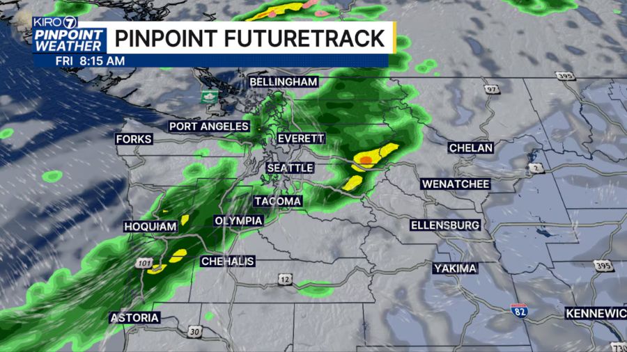
Parts of western Washington, mainly southwest Washington, remain under flood watch until 10 a.m. Saturday, as rain is forecast through the weekend.
Grays Harbor, King, Lewis, Pierce, and Thurston Counties are under flood watch, according to the National Weather Service (NWS). Officials specified Olympia, Hoquiam, Fords Prairie, Tacoma, Seattle, Lacey, Chehalis, Tumwater, and Aberdeen could be impacted.
Rainfall from Thursday, as well as showers expected Friday, could make rivers slower to recede.
“Flooding caused by excessive rainfall continues to be possible,” NWS stated in its report.
Weekend forecast: Steady rain ahead
There is a 100% chance of rain Saturday, with a tenth to a quarter inch expected. The high will be near 45 degrees, accompanied by wind gusts around 14 mph and potentially reaching 22 mph. Saturday night, the chance of rain falls slightly to 90%. A low of 41 degrees is predicted, with wind around 11 mph.
On Sunday, there will be a high near 46 degrees and a 90% chance of precipitation. Sunday night will also see a 90% chance of precipitation with a low around 39 degrees.
“New precipitation amounts between a tenth and quarter of an inch possible,” NWS stated.
Monday will see more rain, with a high near 47 degrees.
Substantial amount of snow in mountains
Anna Lindeman, lead meteorologist at the National Weather Service (NWS), said the mountains saw a significant amount of snow, which means less water is going into the rivers.
“Looking at some reports this morning, it’s a little hard to tell exactly how much snow we did get, just because it’s still snowing a little bit, and some of the stations have gone out with all of the weather that we’ve been having, but it looks like we definitely got a healthy dose of snow over the mountains,” Lindeman said.
As for blizzard conditions, Lindeman said the systems that are coming are much weaker.
“It’s not looking like we’re going to see those blustery conditions like we did earlier this week,” she added.
Several rivers being watched for flooding
NWS is watching several rivers for flooding, including the Skokomish River, Cowlitz River, Chehalis River, and the Cedar River.
“These are all rivers that got some healthy precipitation yesterday with that round of rain that we saw. And we’re primarily concerned with rivers that are mainly south of the Puget Sound, where we got that precipitation yesterday,” she explained.
As for the White River, that is dam-operated, and the dam operators are trying to release water as new water comes in, so there is no overtopping of reservoirs.
“They’re just keeping a close eye on this, just to make sure that there’s no additional flooding. But the water levels there are pretty high. And there’s some variability that could happen over the next several days with the water levels there,” Lindeman said. “But we’re keeping a close eye on it, and the people in charge of the water flow decisions are really trying their best to make sure that there are no additional flooding impacts from what has happened already.”
RELATED STORIES


Beware of landslides
Lindeman added that the threat of flooding is decreasing, but people should still be cautious and be wary of landslides.
“Just because the rain is lightening up, there is still some potential for landslide activity. So I just really want to urge anyone who’s traveling, especially in that steeper terrain, to be a little extra careful and maybe slow down a little bit, because landslides are still possible at this time, pretty much across all of western Washington,” she said.
Follow Julia Dallas on X. Read her stories here. Submit news tips here.