Atmospheric river to bring heavy rain, 50 mph winds to WA this weekend
Oct 23, 2025, 7:53 AM | Updated: 3:04 pm

A photo of people walking through the rain. (Photo: Spencer Platt, Getty Images)
(Photo: Spencer Platt, Getty Images)
Active fall weather is about to hit Western Washington. A strong Pacific weather system is tracking toward the region, which will bring a healthy amount of rain, blustery winds at times, and by late in the weekend, the first good dose of snow in the mountains.
Impressive Looking Atmospheric River
The incoming weather system has sub-tropical moisture embedded in it, which tracks all the way across the Pacific to near Taiwan.

NOAA weather satellite image across the north Pacific that highlights the long stream of sub-tropical moisture extending well into the western Pacific that will accompany the wet and windy storm late Thursday into Friday. (Photo courtesy of the National Oceanic and Atmospheric Administration)
In addition, this system is being driven by the season’s strongest jet stream thus far this season. Up around 30,000 feet, where commercial jets fly, the jet stream has westerly winds of 150 to 200 mph.
RELATED STORIES


Much Needed Rain
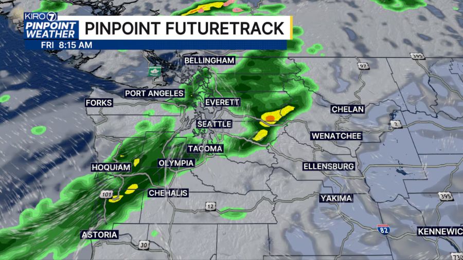
As this system swings onshore, rain will spread inland from the coast late Thursday into Friday. Rain amounts through Friday night will range from two to four inches along the coast and in the mountains, and one to two inches elsewhere in western Washington. These rain amounts will help with the current dry conditions.
The rain will likely be heavy at times, resulting in local ponding of water on roadways, creating the potential for hydroplaning. Motorists should take it easy, slow down, and give plenty of room behind the vehicle in front.
In the mountains, snow levels will be relatively high, above 6,000 feet, through Friday. Given that rivers and streams all have relatively low stream flows, no river flooding is anticipated.
Winds
Strong southerly winds are anticipated to develop ahead of this weather system on Thursday, reaching 25 to 40 mph with gusts to 50 mph overnight along the coast and from Whidbey and Camano Island northward to the Canadian border. Winds elsewhere are expected to be about 15 to 25 mph. Local power outages are possible and something to prepare for in advance.
Storm Drains
The blustery winds will likely knock down leaves from the region’s trees. Combined with the rain, storm drains are likely to accumulate leaves in the rain runoff, potentially clogging the drains and producing water backups on roadways. Local utilities ask residents to help clear storm drains of leaves during this stormy weather.
Falling Mountain Snow Levels This Weekend
This weather system will continue inland on Friday night. Yet another following weather system is forecast to develop off the coast Saturday, producing another bout of wet and windy weather.
This system will also track inland and be followed by a much cooler unstable air mass for showers. By Sunday, mountain snow levels are expected to fall to their lowest levels of the season thus far, close to 3,000 feet. Snow amounts are forecast to range from eight to 18 inches of fresh snow.
Higher mountain passes like Rainy Pass, Stevens Pass, Blewett Pass, White Pass, and Chinook and Cayuse Passes likely get their first significant accumulating snow on and approaching the passes. Motorists need to be prepared for winter weather driving conditions. Snoqualmie Pass, at nearly 3,000 feet, is not likely to have snow collect on I-90, yet it will likely see snowflakes in the air at times.
The rest of western Washington can expect a mix of showers and sunbreaks Sunday, with cool daytime temperatures only in the 50s and overnight lows in the 40s.
Looking Ahead
During the final week of the month, more Pacific weather systems are expected to track onshore with more rain at times. For those planning for trick-or-treaters, conditions appear to be wet. High temperatures during the week will remain rather cool, only in the 50s.
The latest longer-range outlook into early November offers some warming, but with wetter-than-average conditions. Yes, active fall weather is here.
Ted Buehner is the KIRO Newsradio meteorologist. Follow him on X and Bluesky. Read more of his stories here.