Western Washington recovers from snowstorms as melt-out continues
Feb 11, 2019, 5:55 AM | Updated: Feb 13, 2019, 1:28 pm
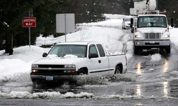
A truck drives through standing water on a highway offramp, Tuesday, Feb. 12, 2019, in Olympia, Wash. after heavy snow turned into rain in the Northwest. (AP Photo/Ted S. Warren)
(AP Photo/Ted S. Warren)
The great melt out is underway as the region warms up. Many roads remain covered in slippery slush, posing issues for commuters attempting to get to a cleared route. The melting snow has also prompted flood and landslide warnings throughout Western Washington.
“You are going to struggle getting out of your neighborhood, certainly on the Eastside, and the north end, until you can get to a plowed street. Once you get there, you are going to be fine,” said KIRO Radio Traffic Reporter Chris Sullivan, noting that many residential areas and other roads are filled with slush. This makes getting to a clear road difficult.
Sullivan heard reports Wednesday morning that snow plows were finally entering neighborhoods in Lynnwood and Snohomish County to clear roads that have been covered in snow and slush.
North Bend has declared a state of emergency with snow piled several feet high. I-90 remains closed in both directions at Snoqualmie Pass. WSDOT says eastbound will reopen at 4 p.m. Westbound will remain closed.
Check below for snow updates over the Wednesday commute.
School closings in the region
Weather forecast
Check Seattle’s snow plow map
Washington mountain pass webcams
Melting out, but risks remain
Earlier this week, University of Washington Meteorologist Cliff Mass said to expect a great melt out,” and that seems to be happening around Western Washington as temperatures hold above freezing.
“From this system, we are out of the woods, and from what’s coming tomorrow, I don’t see a lot that would cause any additional snow issues,” said KIRO 7 Meteorologist Nick Allard. “We dry out this afternoon, it will turn partly sunny and it will get to the upper 30s and lower 40s.”
Though some freezing is possible in places overnight with temps falling into the 20s. Drivers should be cautious and wary of ice.
Warmer temperatures in the 30s held overnight sparing the region from widespread freezing. Most areas around Seattle were hanging around 34 degrees Wednesday morning. Allard says the region can expect scattered showers, especially around Everett and to the north. There is potential for some random wet snow, especially if you are above 300-500 feet. There is more rain forecast for Friday and Saturday.
What’s this?! Temperatures in the lower 40s by the weekend?!? I’m not saying it’s time to break out the Bermuda shorts, but at least we won’t have to order coffee on a stick at the local coffee shop. And I won’t need a team of Huskies and a sled to get to work. #wawx pic.twitter.com/ESfuPO5YG0
— NWS Seattle (@NWSSeattle) February 13, 2019
The National Weather Service warns, however, that lingering piles of snow will make things difficult in Western Washington.
“Because of the amount of snow we’ve had, just the sheer quantity we’ve seen in the last three or four days, it’s gonna take some time to melt that off,” he said. “It’s not going to be like the kind of snowfall where we have an inch or two and it disappears in the space of a day.”
Snow Loads and Other Hazards.
With temperatures rising above freezing in the lowlands, our concerns have shifted from snow to other hazards. The National Weather Service in Seattle has compiled a list of the potential hazards we face this week:https://t.co/rKF0mjlvxd pic.twitter.com/Mb46aHhlXM— Eastside Fire (@EastsideFire) February 13, 2019
Landslides and flooding
The National Weather Service issued a special weather statement cautioning Western Washington about the potential for landslides. Areas below 1,500 are at higher risk. The weather service states:
There is an increased threat of landslides for the lowlands from Snohomish to Jefferson Counties southward. Areas where there is melting snow and rainfall is saturating the soil. The landslide threat will increase through the week and expand northward to the Canadian border and upward in elevation into the foothills as warmer weather continues to move into the region.
Melting snow is very efficient at increasing soil moisture and is not well represented in the landslide indices such that the threat is higher than the indices suggest. Additional rain Thursday will put extra pressure on soil instability, leading to further increased threat of landslides.
The weather service has also issued a flood advisory for the region, effective until 8 p.m. Snow melt is putting pressure on urban and small streams in King and Pierce Counties. This could send rushing water over highways, streets, and underpasses. This is partially caused by street drains being blocked by slush and ice.
Areas that will be affected include: Seattle, Tacoma, Bellevue, Kent, Federal Way, Auburn, Puyallup, North Bend, Carnation, Renton, Redmond, Kirkland, Sammamish, Bothell, Burien, Issaquah, Des Moines, Maple Valley, Covington and Bonney Lake.
Power outages
Reports of power outages continued through Wednesday as rain moved into the region. Puget Sound Energy reported Wednesday Morning that “Since the first snowstorms arrived last Friday … we’ve restored power to approximately 327,000 customers, while approximately 18,000 customers remain without power.”
You can check on outages below.
Puget Sound Energy
Seattle City Light
Snohomish County PUD
Tacoma Public Utilities
Snow commute updates
The following are updates for traffic and weather over Wednesday, including reports from KIRO Radio Reporters Tracy Taylor and Chris Sullivan.
9:05 a.m.
A look at current traffic conditions in the Seattle area ⬇️ pic.twitter.com/ftpzeBe7fp
— WSDOT Traffic (@wsdot_traffic) February 13, 2019
Most major routes through the Everett area in @SnoCounty are bare and wet this morning, but hit a side street or a parking lot that hasn’t been plowed you’ll encounter this sort of travel trauma. #WaSnow #WAwx pic.twitter.com/mzMMpGK9F4
— Snohomish County DEM (@SnoCo_DEM) February 13, 2019
8:55 a.m.
“We are still enjoying a pretty decent drive; just lighter volumes out there,” Sullivan reports. “The heaviest slowing we have is I-5 north and southbound corridor, just south of downtown, toward the West Seattle Bridge.”
“Out of the north end, there are no issues at all, except for getting out of your neighborhood,”Sullivan said. “I just heard from Lynnwood that they just wrapped up their work on major streets so they are working into the neighborhoods now with their plows. I’m hearing Snohomish County is doing the same thing. So they are slowly getting to some of the neighborhoods.”
8:40 a.m.
The sun will come out in many areas today causing snow to continue to melt. Minor flooding is possible, mainly in areas where drains are clogged by snow, ice, or slush. Flood Advisories are in effect through this evening for most lowland areas (green highlighted areas). #wawx pic.twitter.com/HobrXWzYo1
— NWS Seattle (@NWSSeattle) February 13, 2019
8:25 a.m.
Snohomish County Public Works Road Maintenance crews changed shift this morning at 4 a.m. as they continue to plow, sand and salt unincorporated county roads. For more information on the county’s snow response, visit https://t.co/fTcQGSeGbA pic.twitter.com/4PFdMGhBTM
— Snohomish County (@snocounty) February 13, 2019
Buses are full this morning. How’s your commute, folks? https://t.co/VNjDlCw5dK
— Seattle Transit Blog (@SeaTransitBlog) February 13, 2019
7:55 a.m.
“Despite the fact that there are lighter volumes out there, we still have a couple places where you might come across some slowing that you might not anticipate,” Sullivan reports. “One place is northbound 167, coming out of Auburn. There is a couple miles of off-and-on annoying slowing, nothing in the way.”
“Another place we are seeing slowing is southbound I-405 into the Tukwila area … it’s kind of slow from the west end of Renton over through Tukwila into Southcenter,” he said.
A few lingering showers this morning. Use caution on side roads and in neighborhoods this morning as a slushy, slippery mess still remains! #wawx #wasnow pic.twitter.com/fTiCOKIsa0
— NWS Seattle (@NWSSeattle) February 13, 2019
The main hwys are basically bare & wet this morning, but they may still be slick in areas. Take it slow & drive for conditions. Oh, and if you’re bringing your vehicle out of hibernation, make sure you clear the snow off it (roof included) before you leave. Let’s all stay safe! pic.twitter.com/SZXOLmPsqP
— WSDOT Traffic (@wsdot_traffic) February 13, 2019
7:35 a.m.
🚨❄️🚌❄️🚨
RIDER ALERT! Prepare for snow reroutes & delays Wednesday, and BEFORE you ride check if your ROUTE is operating and WHERE https://t.co/QujzOTMXRZ
Then see if your TRIP is operating through Next Departures on our Trip Planner or text your stop ID to 62550. pic.twitter.com/mhKpk1gbew— King County Metro🚨❄️🚌❄️🚨 (@kcmetrobus) February 13, 2019
7:30 a.m.
Amen. Worst neighborhood drive yet. Bouncing around like sand driving. Huge ruts. Neighborhoods just east of you are awful. https://t.co/4VjUBroTK9
— Chris Sullivan (@NEWSGUYSULLY) February 13, 2019
A few lingering showers this morning. Use caution on side roads and in neighborhoods this morning as a slushy, slippery mess still remains! #wawx #wasnow pic.twitter.com/fTiCOKIsa0
— NWS Seattle (@NWSSeattle) February 13, 2019
7:15 a.m.
“That wet-heavy snow is still in a lot of neighborhoods, and causing very tough conditions getting out of your neighborhoods,” Sullivan reports. “I just talked to John Curley and Brock Huard who came in from the Eastside. They said it was by far their worst bumpy drive getting out of their neighborhood. I can say the same thing for Snohomish County.”
Traffic volumes have increased compared to the past couple days, but roads remain fairly light. Travel times from Everett to Seattle or Bellevue is under 40 minutes.
7 a.m.
“We are still dealing with the closure of I-90 over Snoqualmie Pass because of the heavy snow conditions there,” Sullivan says. “You are going to struggle getting out of your neighborhood, certainly on the Eastside, the north end, until you can get to a plowed street. Once you get there, you are going to be fine.”
Back on the roads this morning where the commute NB 5 is slowing down near the Dome pic.twitter.com/Di7JIjlXwg
— TracyTaylorTraffic (@TracyTTraffic) February 13, 2019
6:30 a.m.
A few more people out today. Travel times are great, but we are starting to see building volumes in usual suspect locations.
— KIRO Radio Traffic (@KIROTraffic) February 13, 2019
6 a.m.
“If you can make it to the freeway or the first plowed street out of your neighborhood, you are going to be fine,” Sullivan reports. “The roads are in really good condition, once you get out of that quarter mile from your driveway.”
But he notes that commuters are beginning to feel the “need for speed” as more drivers venture out onto the roads. But many schools are still closed because of the snowy, slushy conditions. That is keeping volumes relatively light.
“There are a few more people on the road that we’ve seen over the past couple of days,” he said. “So we’ve seen some slowing in the usual places, like on the I-5 southbound drive out of the Shoreline area … there is some slowing on northbound I-405 from Sunset into the Newcastle area.”
Follow @http://twitter.com/Mynorthwest