All Over The Map: Was Cold War scarier than COVID-19?
Mar 13, 2020, 11:24 AM | Updated: Mar 18, 2020, 10:24 am
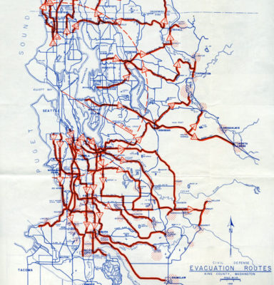
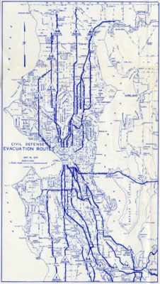


As the Puget Sound area faces the brunt of the COVID-19 pandemic, these can feel like scary times. But it might have been even scarier back in 1955, when the Seattle and King County Civil Defense Departments published maps of evacuation routes for residents to use in the event of a nuclear attack.
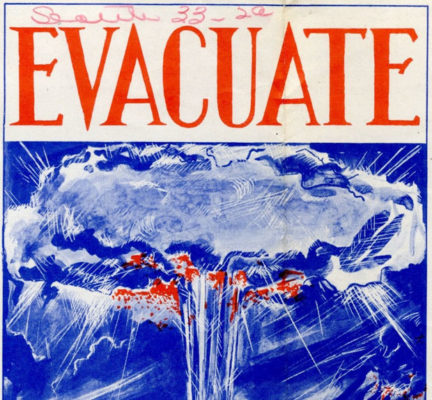
The maps are packaged in a handsome little brochure called “EVACUATE: Don’t Sit Under the Mushroom.” Cover art shows a woman holding a baby and a man wearing what appears to be a sombrero. They are, in fact, sitting at the base of what appears to be a giant mushroom cloud.
Perhaps this pandemic edition of “All Over The Map” should be temporarily renamed “Things Could Be Much Worse.”
And maybe things were much worse, because in the 1950s, the United States and NATO were pitted against the Soviet Union. The world – and the region — was gripped by the Cold War, and it seemed like nuclear destruction was a foregone conclusion.
There were anti-aircraft Nike missile bases on hilltops around the region, including at what’s now Cougar Mountain Park on the Eastside, as well near Bothell, in Redmond, and on Vashon Island.
A giant “community fallout shelter” was even constructed as part of an I-5 overpass near Green Lake. And, because there were military bases and defense contractors here such as Boeing, the Puget Sound area was publicly identified as a target of the Soviets as early as 1954.
“EVACUATE” was published and distributed for free by Seattle and King County as a way to help the public prepare for a crisis, not unlike what’s going on right now online and over the airwaves regarding the pandemic. But, instead of washing your hands for 20 seconds, this was all about getting at least 13 miles away from downtown Seattle in less than two hours in the event a 10-megaton hydrogen bomb was dropped on the city.
What the map shows are routes for one-way traffic from populated areas of Seattle and King County to less-populated and rural areas of south Snohomish and east King County, including Everett, Monroe, Stillwater (near Carnation), and Fall City.
The official name for these destinations was “Reception Areas,” and plans called for “Reception Centers” to be built to house facilities and supplies so that people could live there for weeks after a nuclear attack, to wait for radiation levels to subside.
It’s unclear if any Reception Centers were ever built. However, if recent events are any indication, each center would have required a lot of toilet paper.
The only way these evacuation routes would work was if the Canadian and U.S. military detected Soviet bombers coming in from the north (this was a few years before NORAD – the North American Aerospace Defense Command – was created).
If a Soviet attack came circa 1955, local Civil Defense authorities figured we might have an hour or two before the bombs would fall. Word would be quickly sent to those local authorities at Seattle’s Civil Defense control center in the old Public Safety Building downtown and at King County’s control center in the old Nellie Goodhue School near Shoreline.
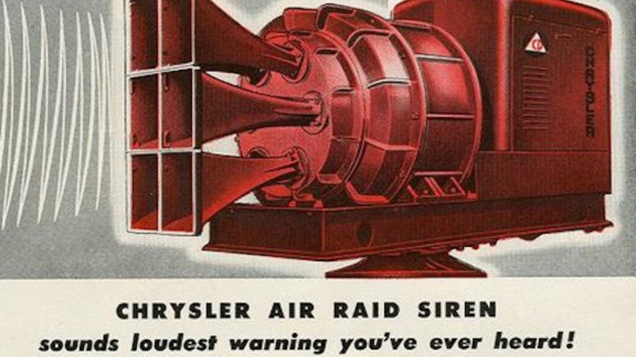
A three-minute long warning blast would then sound through a network of sirens alerting everyone that it was time to get moving.
For those residents in north end, south end, and on the Eastside, there were specific numbered routes to follow to drive to specific Reception Areas. In Seattle, Madison Street was the dividing line that determined whether you were to head north or south to get out of the city following similarly numbered routs.
Apparently, the numbered routes were marked with distinctive signage – similar to the tsunami warning signs nowadays seen in coastal areas.
What to do with school children if the attack came on a weekday was the toughest problem to solve, because authorities in Seattle had to convince parents who, say, worked on the south side of Madison Street to go to a different “Reception Area” than where their kids were headed (if their kids’ school was north of Madison, or vice versa).
Seattle’s Broadview neighborhood held a big drill in late May or early June of 1955 to test the evacuation routes shown on the map, but it’s unclear what the results were. Another drill held in 1957 included a Chinook helicopter dropping leaflets over Lake City to simulate nuclear fallout.
There was some controversy in December 1955 when a state official estimated it would actually take not two hours, but as many as six hours to evacuate everyone from Seattle. D.E Barbey, Washington State Director of Civil Defense, was the same official who had earlier pointed out that the city and county Civil Defense control centers were located within the 13-mile nuclear blast zone.
Seattle and King County got the message about control center locations; King County moved theirs to Kent, and Seattle’s was moved to an old fire station in Lake City. Post-nuclear war contingency plans were also made to create temporary headquarters for King County government in Enumclaw, and a temporary Seattle mayor’s office and city council chambers at Cedar Falls in the Snoqualmie foothills.
By the early 1960s, the difference between two hours and six hours to evacuate didn’t matter anymore. More powerful nuclear bombs meant far bigger blast zones, and faster intercontinental ballistic missiles meant far less, if any, warning time.
Special thanks to Benjamin Helle of the Washington State Archives for sharing this map with KIRO Radio.
You can hear Feliks every Wednesday and Friday morning on Seattle’s Morning News and read more from him here. If you have a story idea, please email Feliks here.