
All Over The Map: Searching for the ‘Devil’s Elbow’ east of Renton
May 8, 2020, 9:11 AM | Updated: 9:11 am

With the pandemic keeping many people closer to home for a longer period than just about anyone can remember, it’s been noted here before that a lot of us are exploring the areas around where we live with new and deeper curiosity.
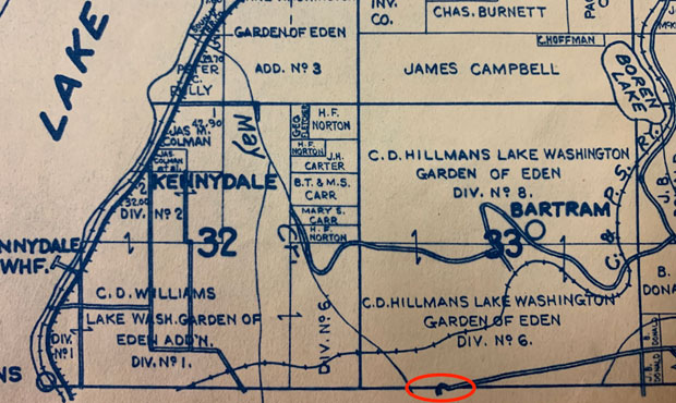
A Facebook friend posted a video the other day of a bike ride down the Honey Dew Creek Trail in Renton east of Kennydale. The trail follows an old roadbed in a ravine along May Creek. This is in the area where the old Columbia & Puget Sound Railroad ran between Renton and Newcastle from the 1880s to 1930s.
In the post, he said this route was called the Devil’s Elbow, and that teenagers used to race up and down it back in the old days. A close look at the trail via Google Maps shows a fairly sharp and dangerous curve about midway down, and then a really sharp curve – almost a “T” – down near the bottom (which is just east of the Kennydale Memorial Hall).
Google Maps, not surprisingly, shows the route, but says nothing about the origins of the satanic name.
And I confess, I’d never heard of a Devil’s Elbow on the Eastside. I grew up several miles north of there on Rose Hill in Kirkland, and we had to settle for the non-demonic but still spooky “Deadman’s Curve” on the Old Redmond Road.
This stretch of roadway is NOT the infamous “Devil’s Elbow,” but it’s not too far from there (maybe this is the “Devil’s Ankle”?). More mashups of satanic anatomy and local geography this morning on @KIRORadio and @Mynorthwest pic.twitter.com/fHnCf1QC6i
— Feliks Banel (@FeliksBanel) May 8, 2020
Elizabeth Stewart, director of the Renton History Museum, shared some old maps of the area and excerpts from oral histories that reference Devil’s Elbow as a dangerous place to drive, and a place possibly associated with moonshine during Prohibition.
It appears that “Devil’s Elbow” was the name that locals gave the roadway because of its treacherousness, but when that name was first applied remains unclear.
Perhaps this was sometime in the late 19th century as more settlers were arriving, and volume and frequency of travel on the old roadway – and maybe accidents at the sharp curve — were increasing. It’s also unclear what year it was first paved.
And those settlers may have been inspired by earlier place-namers elsewhere. The name “Devil’s Elbow” can be found in other English-speaking parts of the world – Scotland, Idaho, California, the Oregon Coast – and it was also applied to a few other Washington state locales.
There’s a Devil’s Elbow on the road (now Highway 2) to Steven’s Pass between Index and Gold Bar; the name was in use there more than a hundred years ago, and was the site of at least one fatal car accident. There’s also rock formation along the Skagit River called Devil’s Elbow, and that name might date back as early as the 1880s.
In the Renton area, the ravine along May Creek became a King County Park around 1970. There was a gravel pit in operation nearby for years, and the ravine was used as an illegal dump by residents.
In August 1970, a child died in an accident at the gravel pit when a sandy hillside collapsed, and the gravel pit was ordered closed soon after. Local serial killer Gary Gene Grant discarded the body of a victim in the ravine around the same time.
Before the Devil’s Elbow was closed to vehicles in the mid 1980s, the official (and much less colorful) name of the road was SE 95th Way. In the area east of Honey Dew Creek Trail, the remaining roadway is now called 95th Way SE.
About a mile north, a nearby stretch of roadway that remains open to traffic and that has its own treacherous curve is SE May Creek Park Drive.
If you know of other unofficial (and hopefully more colorful) names for roads, curves or other geographic places like neighborhoods and parks around Washington, please reach out using my contact information below.
You can hear Feliks every Wednesday and Friday morning on Seattle’s Morning News and read more from him here. If you have a story idea, please email Feliks here.


