
All Over The Map: Roadside monuments mark violent chapter in Washington history
Sep 4, 2020, 9:39 AM | Updated: 10:54 am

Distinctive yet often overlooked monuments at Four Lakes, Spokane Plains, and Horse Slaughter Camp commemorate a violent chapter in Washington history that unfolded more than 160 years ago.
The monuments near Spokane are all related to battles between the U.S. Army and indigenous people that took place during the first week of September 1858. They’re all worth pulling off the road to take a closer look, and taking time to better understand.
Though fraught with a complex backstory, the basic reasons for the battles are tragically simple. What’s now Washington was Native territory for a millennia, and from roughly the 1830s on, settlers and Natives came into often violent and deadly conflict over land, resources, and the future, especially after a hasty and far from perfect treaty negotiation in the early 1850s.
In the 1930s and 1940s, the monuments were created to commemorate what’s commonly known as the Indian War or Plateau War of 1858. This was essentially the last sustained armed conflict between indigenous people and the U.S. Army in what’s now Washington, and what was then Washington Territory. The tribes involved included the Palouse, the Spokane, the Coeur d’Alene, and the Yakima.
The violence that September 162 years ago was rooted in the larger conflict, but stemmed directly from an earlier battle in May 1858. In that engagement, sometimes known as the Battle of Rosalia, but now often referred to as the Battle of Pine Creek, an officer named Colonel Edward Steptoe was leading a group of soldiers and officers from Fort Walla Walla to Colville in response to the death of two miners.
Steptoe’s group came under attack, and seven Americans and perhaps as many as 50 Natives died. The Army managed to retreat under cover of darkness, and it was considered a defeat for the Americans.
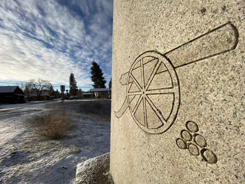
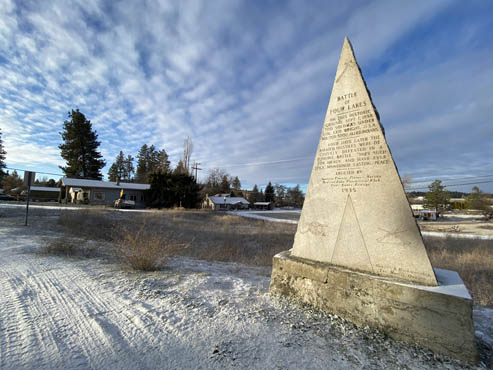
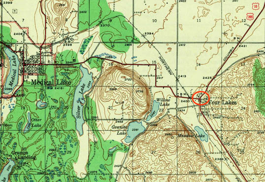
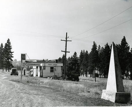
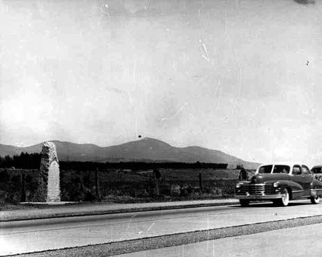
The Battle of Four Lakes took place on Sept. 1, 1858, as part of an effort to quell further violence between Natives and settlers. The monument is right off I-90 near Cheney, not far from the community of Medical Lake, near a quartet of smaller bodies of water that give the area its name. The monument stands alongside what’s now a dead end side street, but that side street was once a major thoroughfare: old U.S. Highway 10, the main east west route across the northern part of the Western United States.
During the battle, a few hundred U.S. Army soldiers fought several hundred Natives from the morning into the early afternoon. Several Natives died, but there were no fatalities among the Americans.
The monument is a jagged pointy triangle with some design flourishes, including engraved illustrations of a stylized cannon and stack of cannonballs. The old stretch of Highway 10 along which it stands is at least as interesting as the monument. Seeing a now decaying slab of concrete highway from the 1920s still in its original location is like visiting a living museum of auto travel from a century ago.
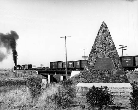
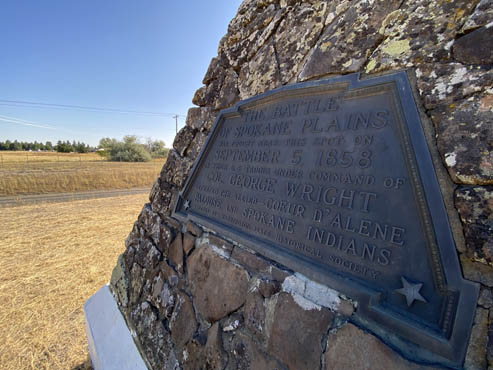
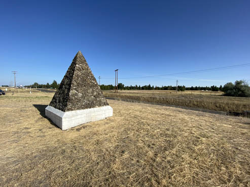
The Battle of Spokane Plains took place about five miles north of Four Lakes on Sept. 5, 1848. When it was dedicated, the monument stood in the middle of nowhere alongside the old Sunset Highway – now Highway 2 – and the mainline of the Great Northern Railway. Since the 1940s, across that same highway has stood Fairchild Air Force Base.
A stout yet tall pyramid made of stones, the monument is striking, and it stands out in stark contrast to its surroundings. With the open plains stretching westward, it’s a stirring spot to think about what this area was like before settlers arrived, and to imagine the complex civilizations that thrived here for thousands of years.
In the Battle of Spokane Plains, several Natives died and the others retreated. Within a few days, some of the remaining leaders of the various tribes involved asked for a negotiated peace. The U.S. Army official in command – Colonel George Wright – agreed, but insisted on complete and total surrender.
On Sept. 8, 1858, as an uneasy peace was taking hold, troops discovered Natives attempting to move hundreds of horses out of the area. The Army put a stop to the move. Over the next few days, the Americans killed as many as 600 horses, depriving the Natives of a valuable resource. These actions were consistent with other steps taken by Wright’s men around this time, such as burning stores of wheat and other supplies belonging to the Natives.
The Horse Slaughter Camp monument stands just west of the Washington-Idaho border along what’s now the Centennial Trail. Its design is more traditional; it’s a fairly simple monolith, and is not as visually striking as the other two.
George Wright was revered as a hero by many for his leadership in the war of 1858, but his tactics now strike many historians as barbaric and extreme. Besides the hundreds of horses, Wright was quick to hang Natives suspected of killing Americans, often just moments after the conclusion of truncated and likely dubious trials. As many as 16 Natives may have died this way under Wright during that summer of 1858.
For many, this represents a brutal double standard — to treat enemy combatants during wartime as though they had committed a murder during peacetime. This is not unlike the circumstances surrounding the execution in Pierce County and ultimate exoneration of the Native leader Leschi.
George Wright had a long military career before 1858, and during the Civil War he was put in command of the U.S. Army in California. In July 1865 after the war ended, General Wright was on his way back to assume command of the Army in the Pacific Northwest when he and his wife were lost at sea in the wreck of a ship known as the Brother Jonathan.
An army base in Spokane was named in 1899 in honor of Wright. It closed after World War II and in the 1950s became a community college campus. A roadway nearby is still called Fort George Wright Drive; various groups have been trying to rename the street for many years.
Standing alongside any of these monuments in 2020 and trying to take in the full weight of what’s being commemorated can evoke many complex and strong feelings. Most of all, it’s a reminder that to fully appreciate stories of 19th century Washington Territory requires time, patience, and infinite amounts of history and context.
You can hear Feliks every Wednesday and Friday morning on Seattle’s Morning News and read more from him here. If you have a story idea, please email Feliks here.


