Snow piles up in the mountains as driving conditions worsen along I-90
Nov 13, 2020, 5:49 AM | Updated: 10:48 am
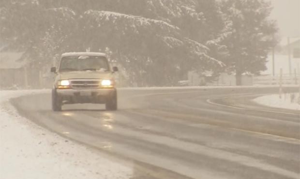
Snow continues to fall in the passes. (KIRO 7)
(KIRO 7)
Heavy snow continues to pile up in the mountains, making travel over the passes difficult for the next few days.
Washington mountain pass webcams
Eastbound I-90 was closed at Denny Creek at 5:30 a.m. Friday due to near-whiteout conditions and multiple crashes and spinouts, before reopening shortly after 6 a.m. Chains are required for any drivers in the area.
In the lowlands Friday morning, it was pouring with breezy to windy weather. Meteorologist Nick Allard said rain will stay steady through most of the morning before tapering off to showers and sunbreaks. There could be an isolated thunderstorm after the cold front, especially west of Puget sound.
As of Friday morning, 11 inches of snow had fallen at Snoqualmie Pass, Stevens had 8 inches, and 21 inches accumulated at Mount Baker.
Meteorologist Nick Allard said one computer model showed a new round of heavy snow could bring more than a foot or more at Snoqualmie Pass and even more at White and Stevens passes by Saturday night.
On Thursday night, I-90 closed in both directions around 11:10 p.m. between North Bend at milepost 34 for drivers going eastbound, and Easton at milepost 71 for drivers headed westbound due to spinouts and collisions, the Washington State Department of Transportation reported.
Both directions have since reopened, but drivers are warned to use extreme caution, slow down, and allow plenty of space between vehicles during the winter driving conditions. Chains are required on Snoqualmie Pass except for all-wheel drive vehicles.
Chief Meteorologist Morgan Palmer said winds areawide in the lowlands would remain in the 20-35 mph gust range with plenty of rain.
On Friday, a trough of low pressure is expected to move across the area, bringing continued breezy weather with wind gusts in the 25-35 mph range but nothing too extreme. Snow will continue to fall in the mountains with another foot of snow on top of what falls tonight, with the exception of Snoqualmie Pass, which might have a changeover to rain on Friday morning. The change will limit further snowfall to the “less than a foot” range on Friday. Nonetheless, pass travel trouble will remain common.
In the lowlands, aside from the aforementioned breezes, it’ll be showery but not raining constantly. There is a slim chance of a thunderstorm Friday afternoon, particularly nearer the coast, but we’ll be watching for any lightning strikes. These could happen anywhere but they won’t be that common.
At the Pacific beaches, there will be some beach erosion and waves in the 13-16 foot range but nothing extreme. There could also be some minor flooding with high tide on the west and south-facing locations of Puget Sound in the early-mid afternoon Friday (12-3 p.m.) as tides will be abnormally high. This shouldn’t be a big deal and is common around King tide season. Some spots like Mukilteo and Edmonds could have some of the waterfront parking lots or trails swamped briefly.
Highs will be in the 40s to around 50 in the lowlands Friday.
As for Saturday, expect showers and sunbreaks, but it will not be as windy. Some mountain snow will continue to fall but hopefully travel will be better through the passes.
WATCH: Snow coming down at #SnoqualmiePass right now from the @SummitSnow411 cam. See you now for more on @KIRO7Seattle. #wawxhttps://t.co/GvXGU6jkwu pic.twitter.com/wF5jO0vmNw
— Morgan Palmer (@MorganKIRO7) November 13, 2020
Over the mountains, multiple ski resorts tweeted that several inches of snow have already fallen, and they are expecting more.
It’s stacking up out there, 15-20” already with more on the way! pic.twitter.com/0mDZ2eliZG
— Crystal Mountain (@CrystalMt) November 11, 2020
Snowfall is ramping up at Stevens Pass; the forecast is calling for more in the coming days! There's less than a month until our scheduled opening day, so make sure to book your Priority Access Reservations with your Epic Pass to get on mountain. #PurePNW pic.twitter.com/AObWeipUdi
— Stevens Pass (@StevensPass) November 11, 2020
Look for pockets of showers on Sunday and then rain into next week.
KIRO 7 meteorologists Nick Allard and Morgan Palmer contributed to this report.