All Over The Map: Reviving the spirit of historic US ROUTE 10 through Washington
Sep 3, 2021, 8:21 AM | Updated: 1:50 pm
It may not have the cachet of Route 66, but an Eastern Washington man is leading the charge to raise the profile of historic US ROUTE 10 all across the state.
US ROUTE 10 is the name of the old federal highway that first crossed much of the northern United States – connecting Seattle to Detroit – beginning around the late 1920s. The road was also known as the Sunset Highway, and whatever it was called, much of it was wiped out — or built over the top of — to create the Interstate 90 freeway in the 1960s and 1970s.
Though most of the old road is buried under newer freeway, there are some great stretches – in some places, up to 40 miles long – where the vintage two-lane highway still exists in the Evergreen State. And in some cases, the old highway is what still goes through the middle of a cool, old rural town – because the straightened and realigned path of I-90 actually bypassed many of the small towns where US 10 was once the main street.
John Rankin is a business owner and civic leader in the Adams County town of Ritzville. He runs a sign company; he restored and operates the historic Ritz Theatre; and he’s also president of the Ritzville Downtown Development Association.
With inspiration from time spent around Route 66 in the Southwest, Rankin has been leading an effort since 2012 to draw attention to old stretches of Highway 10 – and to those little towns, such as Ritzville and the Lincoln County community of Sprague — that are still charming, and that still could use your business if you need gas or a sandwich, or maybe a used book or an antique.
“Basically, our thing is just to get more tourists off the freeway, as opposed to just going to the Starbucks and McDonald’s by the freeway,” Rankin told KIRO Radio, “but to [instead] venture off a mile or so off the freeway and drive through these old towns and hopefully provide some sort of economic boost.”
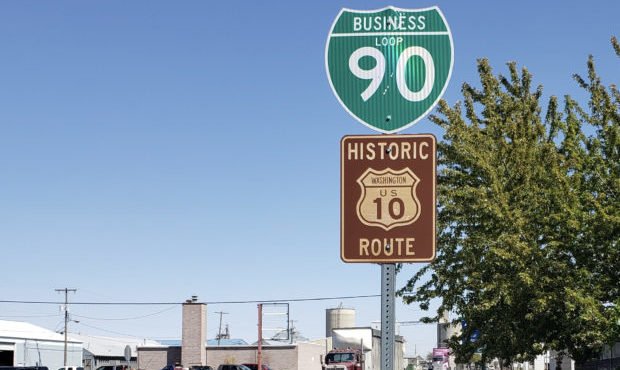
The main focus of Rankin’s effort so far is signage – along the freeway and along the old stretches of Highway 10. The first signs went up in Sprague; Rankin designed and fabricated them himself, following all the appropriate rules for roadside signage. Then, a few years ago, the State Legislature devoted $50,000 to the project, which means there are small signs at several exits along I-90 in that long stretch between Moses Lake and Spokane. The signs are brown, they feature the old US Highway logo, and say “HISTORIC WASHINGTON US ROUTE 10.”
When a motorist on I-90 sees one of those new signs – which are typically attached to each of two directional signs that note an upcoming exit – it means the motorist can leave the freeway, and then follow part of old US 10 for some distance, and then easily get back on the freeway.
For those exiting I-90 to take old Highway 10 through Ritzville, for example, there are larger vintage-style “Highway 10” signs along the old two-lane road. These local signs – not on the I-90 freeway – are up to the individual jurisdictions to create and install, and they help unfamiliar drivers know that they’re on the right path.
Exploring old Highway 10 is possible here and there along almost all of I-90, from Idaho to Seattle. There are old stretches of Highway 10 in the urban areas just outside of Spokane; in Cle Elum on the road connecting I-90 to US 97 and Blewett Pass; in North Bend and Snoqualmie; in Issaquah; and even on Mercer Island.
One thing that makes this kind of roadway exploration somewhat challenging is that there’s currently no really good brochure or map showing all the stretches of the phantom Highway 10. The project could benefit from a dedicated app, or if it was marked in some way on Google Maps and Apple Maps so that a smartphone user could select the old highway, and then get turn-by-turn navigation instructions.
Until there is an app, for those drivers really devoted to going old-school, Rankin has a recommendation that’s based on how he first identified the old stretches of highway nearly a decade ago.
“You’ve just got to find an old 1950s or early 1960s gas station road map,” Rankin said. “Then you take that and overlay it with [a newer] one with the freeway on it.”
You can hear Feliks every Wednesday and Friday morning on Seattle’s Morning News, read more from him here, and subscribe to The Resident Historian Podcast here. If you have a story idea, please email Feliks here.

