Rain finally returns to western WA after 14 days, here’s what lies ahead
Jan 28, 2026, 1:33 PM | Updated: 1:51 pm
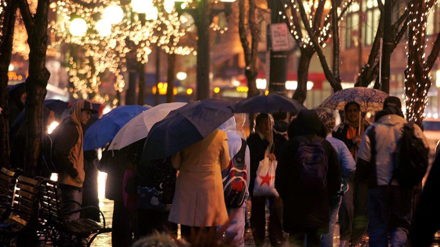
Commuters carry umbrellas as they wait for buses in Rainier Square on 4th Avenue during evening rush hour. (Photo: Robert Sumner, Getty Images)
(Photo: Robert Sumner, Getty Images)
It happened. It finally rained. After 14 consecutive dry days, western Washington finally received some measurable rain overnight on Tuesday. The 14-day stretch of dry mid-winter days fell just shy of the record at Seattle-Tacoma International Airport (SEA) of 15 days set in 1963.
Going back through all Seattle weather records dating back to the 1890s, the all-time mid-winter dry streak record set at the Seattle Federal Building in 1901 was 18 days. Another long mid-winter dry streak came in 1915 with 14 days, and this month’s dry streak tied that mark.
RELATED STORIES

Below average rain this month
After a wet start to the month, the 14-day period of dry weather has resulted in below-average rainfall across western Washington. As of midnight Tuesday, SEA has received 3.38 inches of rain this month, more than an inch and two-thirds below average. Olympia is more than three and two-thirds of an inch of rain below average.
Big change to wetter weather
The big ridge of high pressure aloft that steered Pacific weather systems well to the north for two weeks has weakened and moved inland, opening the door for weather systems to move ashore. Several weather systems will spread rain into western Washington at times through the weekend, though Saturday looks like a break in the rain. Expected rain amounts, though, will quite likely not be enough to make up this month’s rain deficit.
Temperatures are expected to rise above average as well. High temperatures will warm into the 50s, with lows only dropping into the 40s. The average high temperature in late January is in the upper 40s.
Mountain snow status
The period of mid-winter dry weather has not been good for an already hampered mountain snowpack. At mid-month, the NW Avalanche Center reported the Olympics and Cascades were only ranging from 40 to 55% of average snow depth. And no snow had fallen until Wednesday, and that snow has been quite light.

A photo of Washington’s Snow Water Equivalent percentages. (Photo courtesy of the United States Department of Agriculture)
The Natural Resources Conservation Service monitors the amount of water in the snowpack and reports that the water content ranges from 35-45% of average, with the exception of around 80% in the North Cascades.
The incoming weather systems through this weekend are expected to drop some much-needed snow in the mountains. Snow levels are expected to be around 4,000 feet to start, but by Thursday and through the weekend, they are forecast to rise between 5,000 and 6,000 feet. So any accumulating snow will be limited to higher elevations.
The return of the upper ridge
Early next week, weather forecast charts point to a return of high pressure aloft over the Pacific Northwest, once again steering Pacific weather systems away from the region. This weather pattern will likely keep western Washington and the mountains dry for the rest of next week.
This return to dry and mild weather does not bode well for any kind of mountain snowpack comeback. The snowpack usually reaches its peak around April 1, leaving less than two months to make a return to at least average.
Temperatures heading into early February also look to be unseasonably warm. Some western Washington locations could crack the 60-degree mark, giving an impression of an early spring. Record high temperatures during this time period are in the lower to mid-60s.
Longer-range outlooks through much of February fail to offer any significant cooler and wetter weather. The odds favor warmer-than-average temperatures and near or below-average precipitation.
Future impacts on WA
Unless the expected dry mild weather pattern changes in February to cooler and wetter weather through March, there will be limited water supply impacts later this summer and fall. Those impacts include enough water for irrigation, particularly for eastern Washington agricultural areas, electric power generation, enough water for fish and recreation, and even consumer water supplies could be impacted.
A limited mountain snowpack could also mean an earlier start to the wildfire season for the entire Pacific Northwest, as well as much of western Canada. Wildfires also mean smoke and poorer air quality.
Relish the rain through this weekend and the refreshed air quality. The region just needs more of it heading into spring.
Ted Buehner is the KIRO Newsradio meteorologist. Follow him on X and Bluesky. Read more of his stories here.