Light snow falls across Puget Sound region Tuesday evening
Feb 23, 2021, 10:26 PM | Updated: Feb 24, 2021, 12:09 pm
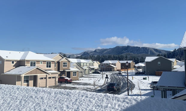
Snow in Enumclaw on Feb. 24, 2021. (Photo courtesy of KIRO Radio listener)
(Photo courtesy of KIRO Radio listener)
Light snow fell across parts of the Puget Sound region Tuesday evening, but it won’t be sticking around.
“It will be melting pretty quickly through today as we’re expecting high temperatures in the 40s and partly cloudy skies,” said Justin Pullen, meteorologist with the National Weather Service.
The National Weather Service in Seattle had warned that rain, snow, graupel, and hail could fall through the night at low elevations in convergence zones.
“Portions of the Puget Sound lowlands saw snowflakes mixed in with rain and small hail last night, but not everywhere saw accumulation,” Pullen said.
7 PM Update | This is one of those evenings where we get a little bit of everything under the active convergence zones – rain, small hail, graupel, wet snow – did we forget anything? Thanks too for your reports of what you’re seeing – we see them and appreciate them! #wawx pic.twitter.com/gz9VYoqNW9
— NWS Seattle (@NWSSeattle) February 24, 2021
The light snow mostly landed north and south of downtown Seattle, moving from south Everett into Lynnwood, Mill Creek, and Edmonds with the north line of snow. To the south, snow moved through Maple Valley, Black Diamond, and into Enumclaw.
Pullen says areas in higher elevations — like Enumclaw, closer to the Cascades — saw up to a couple inches of snow, and even some hail.
The Enumclaw and Willapa Valley School Districts are both starting two hours late Wednesday, with no morning preschool and buses on snow routes.
Check for school closures and delays
Snow was reported in areas of Stanwood, Snohomish, Maple Valley, Everett, Enumclaw, Port Townsend, Lake Stevens, Bonney Lake, Edmonds, Tacoma, Auburn, Puyallup, Federal Way, and Black Diamond.
KIRO 7 Meteorologist Morgan Palmer says we’ll get a drier break on Wednesday before rain returns on Thursday. Showers will continue Friday and into the weekend.
Meanwhile, a Winter Storm Watch is in effect for the Cascades from Wednesday evening through Friday evening above 2,000 feet where heavy snow is possible. The NWS says total snow accumulations of 18-30 inches are possible at the passes, and winds could gust as high as 40 mph. Travel could be very difficult to impossible.
In the Olympic mountains and valleys, including Hurricane Ridge, there’s a Winter Weather Advisory in effect from 10 p.m. Wednesday to 10 a.m. Friday. Total snow accumulations of 8-21 inches are possible.
Follow @http://twitter.com/Mynorthwest