
90-degree days are back in western Washington, and more are coming as summers grow longer
Jun 22, 2026, 6:26 AM | Updated: 3:24 pm

Boaters drift on Lake Union on a hot summer day. (Photo: Karen Ducey, Getty Images)
(Photo: Karen Ducey, Getty Images)
The National Weather Service’s Climate Prediction Center (CPC) recently released the latest seasonal weather outlook. The outlook for this summer continues to reflect warmer and drier-than-average conditions. This summer weather trend has been the case for much of this century thus far.
Just recently, the first 90-degree days in western Washington unfolded. This week, another surge of unseasonably ‘hot’ weather makes it likely that temperatures will reach 90 degrees again, and it’s only June.
Summers getting longer?
Does it seem like summers are getting longer? Several studies in the last 15 years show that this is the case worldwide. A new study of worldwide temperature data by scientists at the University of British Columbia has found that summer starts earlier, lasts longer, and is hotter than it used to be. In fact, the study found summers are now six days longer per decade, up from four days per decade in a previous study completed in the early 2010s.
Weather statistics for western Washington reflect this trend toward longer, hotter summers. In the 20th century, Seattle averaged only three days per year with temperatures of 90 degrees or more. So far this century, that average has risen to five days per year, and in just the last 10 years, the number of days reaching 90 degrees or higher has risen to eight per year.
Just five years ago, in late June, temperatures across much of western Washington reached 100 degrees or higher for three consecutive days, shattering previous all-time records. And on October 16, 2022, Seattle hit 86 degrees, the warmest temperature ever for so late in the year.
El Niño
There has been growing discussion lately about the developing El Niño in the tropical waters of the eastern Pacific. Some are describing it as “strong,” “super,” or a “monster” El Niño. El Niño impacts Northern Hemisphere weather patterns primarily during the winter season.
Spring season predictions of a coming El Niño have a history of error. Yet, sea surface temperatures in the tropical Eastern Pacific are showing a sharp rise and have turned the corner from this past winter’s weak La Niña to a weak El Niño, with a warming trend.
In a recent El Niño-related statement, the CPC indicated a “63% chance of a very strong El Niño during November-January that would rank among the largest El Niño events in the historical record going back to 1950.”
What does this El Niño mean?
In the Pacific Northwest, El Niño winter season conditions usually mean warmer-than-average temperatures and, often but not always, drier-than-average precipitation.
In the wake of four straight below-average mountain snowpack winter seasons, another dismal snowpack this coming winter is not good news. In addition, this El Niño would quite likely extend current dry conditions into 2027, with more limited water supplies heading into next summer, which the CPC indicates will be another warmer and drier-than-average season.
Currently, Eastern Washington is already suffering moderate to severe drought conditions. Western Washington conditions are in better shape, with just limited areas in abnormally dry status. 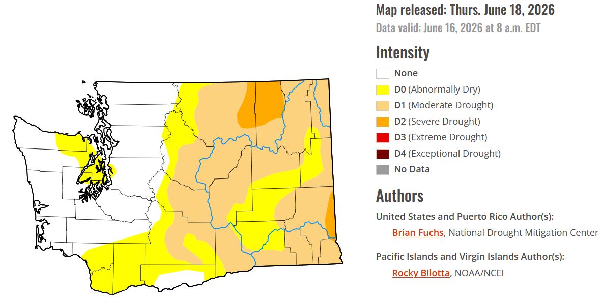
This week’s surge of unseasonably warm weather will amplify the dry conditions statewide. For at least western Washington, there is some coming relief from the heat and dryness. A Pacific weather system is forecast to punch its way onshore late this week, bringing clouds, much cooler temperatures, and even some rain.
Yet, if longer-range weather charts are on track, that rain may be the last to be seen this month.
Heading into July, the usually warmest and driest month of the year, the summer weather outlook points toward more periods of quite warm temperatures through September.
RELATED STORIES

Wildfires
Another longer, hotter, and drier-than-average summer indicates a growing threat of wildfires. Already, Eastern Washington has experienced well over a dozen wildfires in just the past few weeks. Western Washington will likely see some wildfire starts, including roadside fires, by mid-July as conditions continue to dry out.
What can you do
There are actions that can help prevent wildfires, including urban-interface wildfires like those that occurred in Bonney Lake during the 2020 Labor Day weekend and, more recently, in the Spokane area. Both events suffered burned homes. These fires, as well as the LA fires in January 2025, included wind-blown embers that landed on roofs and properties miles from the originating fire.
- Build defensible space around your home or business. Visit the National Fire Protection Association for steps to take, such as:
- removing stacked firewood away from your structure
- clear debris from roofs and gutters
- trim tree limbs up to head level to avoid a “ladder climbing” fire from reaching into trees
- avoid outdoor burning
- Abide by local burn bans
- With the Fourth of July just weeks away, avoid the use of fireworks and attend local fireworks shows
- Tighten chains on towing vehicles to avoid sparks on the pavement
- Keep burning materials inside vehicles
- When camping, ensure the campfire is cold before leaving
According to the National Interagency Fire Center in Boise, Idaho, by August, all of Washington will face an above-average wildfire threat.
Wildfire smoke
Wildfires also produce smoke and poor air quality. In western Washington, the region has suffered from wildfire smoke in seven of the last nine summers, dating back to 2017, when smoke from British Columbia wildfires spread into the area. You can always monitor the latest air quality readings from the Washington Dept. of Ecology’s air quality map.
And remember those N-95 masks from the recent pandemic? Use them during periods of wildfire smoke to keep minute wildfire particles from reaching your lungs. Once there, those particles remain in place.
Weather forecasters, fire agencies, and water supply managers are all keeping an eye on the weather until the fall rains arrive. Enjoy the summer, just do so safely, and take precautions from the hot weather and the possibility of wildfires and smoke.
Ted Buehner is the KIRO Newsradio meteorologist. Follow him on X and Bluesky. Read more of his stories here.













