Blizzard warning issued for Cascades and Olympics as up to two feet of snow looms
Dec 16, 2025, 1:03 PM
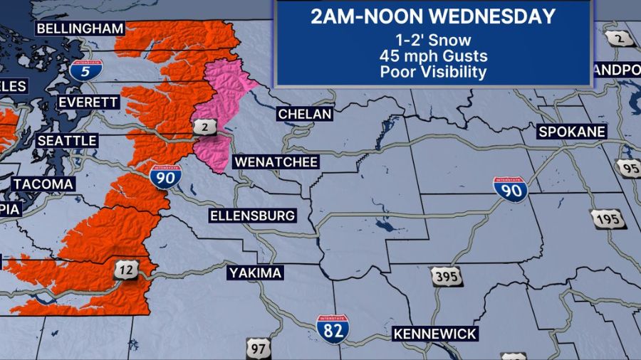
Map of western Washington displaying the blizzard warning. (Photo courtesy of KIRO 7)
(Photo courtesy of KIRO 7)

A blizzard warning has been issued for a huge swath of the Cascade and Olympic Mountains.
The National Weather Service’s (NWS) winter storm warning was upgraded to a blizzard warning. One to two feet of snow is expected at or above 2,000 feet. According to KIRO 7 meteorlogist Nick Allard, 10 to 20 inches of snow are possible, with windy weather and poor visibility.
The blizzard warning will be in effect from 2 a.m. to 12 p.m. Wednesday, as of this reporting.
In addition to the blizzard warning, winds will also gust as high as 45 miles an hour, making travel in the area treacherous due to low visibility and possible tree damage.
Westerly gusts of 40-55 mph are expected late afternoon and overnight. Isolated gusts above 55 mph cannot be ruled out. The strongest winds will be across the coasts, high elevations, and the Strait of Juan de Fuca. #WAwx pic.twitter.com/kmHz7DyCmO
— NWS Seattle (@NWSSeattle) December 16, 2025
Multiple hazardous weather conditions in western WA
Westerly gusts of 40-55 mph are expected late afternoon and overnight. Isolated gusts above 55 mph cannot be ruled out. The strongest winds will be across the coasts, high elevations, and the Strait of Juan de Fuca — where a gale warning is currently in place.
High wind warnings are in effect for the Puget Sound lowlands and coastal areas from 4 p.m. Tuesday until 6 a.m. Wednesday.
Flood warnings will continue until further notice for the Skagit River near Concrete and Mount Vernon.
East of the mountains, winter weather advisories and winter storm warnings are also in effect.
This is a developing story, check back for updates
Follow Frank Sumrall on X. Send news tips here.