Historic atmospheric river eases, but landslide threat lingers as more rain looms
Dec 12, 2025, 6:49 PM | Updated: 6:52 pm
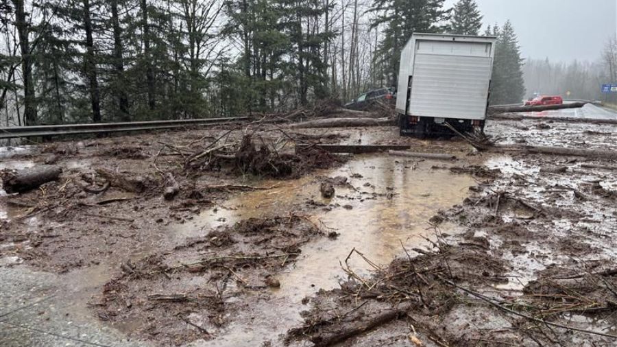
A landslide closed eastbound I-90. (Photo courtesy of WSDOT)
(Photo courtesy of WSDOT)
The worst of the heavy rainfall may be over, but more rain is on the way early next week.
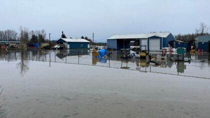
Nearly every river that rose well above its banks this week is receding. For those rivers at the major or record levels, it is going to take time to fall back within their banks. Most will achieve that goal this weekend, but a few will remain above flood stage into early next week. For the latest river and flood forecast information, visit the National Weather Service Rivers and Lakes webpage.
Historic event?
This atmospheric river, heavy rainfall event, was one of the more significant events in recorded history. Many rivers rose to near record levels that were set in big floods like in January 2009, December 2007, November 2006, November 1995, or November 1990.
A few rivers set new record high flood levels. The Skagit River at Mount Vernon crested at 37.7 feet just after midnight Friday, nipping the previous record of 37.4 feet.
The Snohomish River at Snohomish also established a new record flood level, reaching 34.15 feet near 5:30 p.m. Thursday, breaking the previous record of 33.5 feet. The Puyallup River at Orting tied its previous record of 21,500 cubic feet per second (cfs) near 4:30 p.m. Thursday.
How much rain fell
This atmospheric river produced copious amounts of rain with snow levels up to at least 7,000 feet. In the Cascades, from Mt. Baker to White Pass, rain totals Monday through Thursday this week ranged from 9 to 15.5 inches.
In western Washington, Seattle-Tacoma International Airport (SEA) received 3.44 inches from Monday through Thursday. Olympia got 5.12 inches during that same time period, and Bellingham got 3.38 inches. Along the coast, Hoquiam recorded 5.35 inches of rain while Forks measured 5.84 inches.
Daily record rainfall fell on Monday, December 8, at Olympia (3.03 inches), Forks (2.52), and Hoquiam (2.92), while SEA (1.60) and Bellingham (2.28) set a new daily record on Wednesday, December 10.
SEA was more than 8 inches behind for the year on rainfall before the week’s rain set in, and the recent wet weather cut that rain deficit down to under 6 inches.
During much of this soggy event, though, the Olympic rain shadow played a role for parts of the North Sound. As an example, Everett-Paine Field received just 1.37 inches during those four days, and the Doppler weather radar clearly showed the absence of rain to the lee (east) side of the Olympic Mountains at times.
The weather in western Washington is clearly terrain-driven, as this soggy atmospheric river event demonstrated.
More precautions
It is going to take time for the rivers to recede back into their banks. Evacuations of low-lying areas continue until further notice. Local authorities will give the “all clear” to return to homes and businesses when it becomes safe to do so.
In the meantime, continue to avoid driving around high water – road closed signs. Remember – turn around, don’t drown. Driving on water-covered roadways is the leading cause of flood-related fatalities. These precautions are all about the safety of life.
Landslide threat
The threat of more landslides will linger through the coming weekend and likely into next week. Soils in the upper layers are soaked and heavy. On steep slopes, those unstable soils could slide. Be wary of the potential of additional landslides. Common slide areas include Magnolia, West Seattle, the Tacoma Narrows, the Hood Canal region, steep slopes in Snohomish and Skagit Counties, and many other areas.
Another warm, wet storm
Unfortunately, the warm, wet weather is not quite over yet. After a dry day with some sunshine Saturday, a weak weather system will spawn some showers on Sunday.
Right on that system’s heels, though, is another wetter weather system that will spread rain onshore Monday. This system also has some warm, moist subtropical moisture embedded within it for another dose of heavier rainfall with high snow levels. Fortunately, this system will be shorter-lived and produce less rain than what fell this week.
Expected rain amounts in the Olympics and Cascades Monday and Tuesday will range from 4 to 7 inches. The coast is forecast to receive another 2 to 4 and a half inches, and the interior of Western Washington, a range of 1 to 2 and a half inches of rain.
Nevertheless, more rainfall will keep river levels high with the potential for additional flooding. This situation bears watching. The extra rainfall will also maintain the threat of more landslides.
RELATED STORIES


Some good news!
This warm, wet weather system’s associated cold front is forecast to swing onshore by late Tuesday, bringing much-needed cooler air, dropping snow levels down to below the passes. Showers are anticipated Wednesday and the rest of next week in western Washington lowlands, with more seasonable high temperatures mainly in the 40s. But in the mountains, the showers will fall in the form of snow.
The recent rain has also helped fill thirsty area reservoirs such as Ross Lake on the Skagit River and the upper Yakima River lakes following a very dry year.