Clouds in the morning and sun in the afternoon will mark the weekend forecast
Sep 18, 2026, 3:43 PM
(Photo courtesy of KIRO 7)
(Photo courtesy of KIRO 7)
We’ve enjoyed two beautiful sunny days in a row, but this weekend will be a little different.
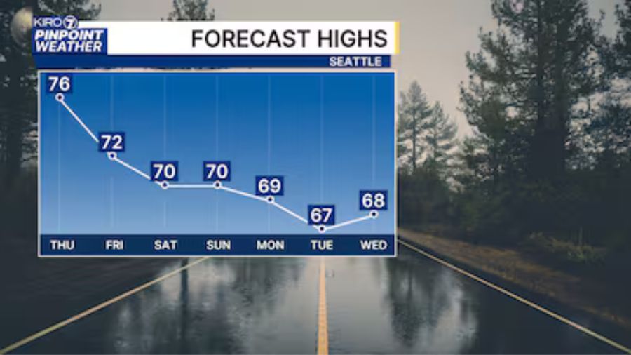
You can expect overcast conditions to start the day on Saturday, and partly cloudy, mostly sunny skies by the end of the day. Some places south of Seattle enjoyed a warm afternoon yesterday, but the chance for another 80-degree day is not in the cards anymore.
We’ll have high temperatures Saturday, and Sunday, we’ll register in the lower 70s. Cooler locations around the Salish Sea will stay in the upper 60s.
Sunday, we will do a repeat performance from Saturday, with cloudy skies in the morning and sunshine in the afternoon. Models are hinting that Sunday might not be as cloudy as Saturday. The best “weekend pick” weather day looks to be Sunday. It will be a dry weekend with no significant rain in the forecast.
Checking out the forecast models for next week, it does look like there will be a shift in the weather pattern. High pressure in the Pacific will move away from the West Coast and allow for a low-pressure trough to develop offshore and extend south.
This will open up the path for weather systems to move toward the Pacific Northwest with clouds and rain showers. This forecast isn’t necessarily “set in stone,” but we will keep track of the potential for rain showers returning in about a week.
We’ve enjoyed some beautiful early fall weather this past week. Next week will likely look a little different. Here’s an interesting statistic — since June 1, only 14 days of measurable rain have been recorded at SeaTac Airport. That means that for the last 110 days, it’s only rained 13% of the time. Sooner later, it will be time to pay the piper!
Have a great weekend.