Western WA windstorm: ‘Wall of wind’ threatens Whidbey Island, Snohomish County
Dec 16, 2025, 7:31 PM | Updated: Dec 22, 2025, 10:20 am

Emergency vehicles operate near a closed off area as wind storm nears. (Photo courtesy of KIRO 7)
(Photo courtesy of KIRO 7)
Charge your devices now. Get your flashlights ready. If you live anywhere near the Strait of Juan de Fuca, Whidbey Island, or Snohomish County, Tuesday night could be a long night.
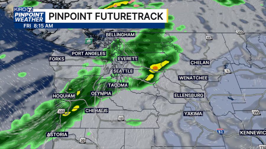
Washington may be in for a rougher ride than initially forecasted. Meteorologists are growing increasingly concerned about a powerful surge of westerly wind expected to race down the Strait of Juan de Fuca late Tuesday night, slamming into the islands and mainland with potentially damaging gusts. With soils still saturated from two weeks of record rainfall, downed trees and widespread power outages are likely.
“It will be a windy night across western and central Washington, and with soils saturated, we could have downed trees,” Morgan Palmer, a meteorologist with KIRO 7, said. “The worst will be late tonight and overnight. Make sure you have devices charged!”
The latest forecast models are showing a troubling trend, and some meteorologists say this could be one of the strongest westerly wind surges in years.
RELATED STORIES

‘Wall of wind’ racing down the Strait of Juan de Fuca
Scott Sistek, meteorologist and author of the Emerald City Weather Blog, said high-resolution models are showing a powerful surge of west wind that could catch many off guard.
“This would in essence bring a ‘wall of wind’ rolling down the Strait past Port Angeles and Sequim, and then crashing into Whidbey and Camano Islands, Port Townsend, before slamming into western Snohomish County and Admiralty Inlet,” Sistek wrote.
What makes this particularly dangerous is the sudden onset.
“The models show rapid intensification of the winds from nearly calm to raging 50-60+ mph in short order,” Sistek said.
High Wind Warnings are already in effect for the area, with gusts up to 60 mph expected and isolated gusts potentially even higher.
Worst-case models show 55-70 mph gusts across Puget Sound
Some forecasters are watching even more alarming scenarios.
Jonathan Pulley, who covers Whidbey Island weather on X, said the newest model runs show a worst-case scenario.
“It has the cyclone develops more quickly, leading to a damaging 55-70 mph west-northwest surge of wind from Port Angeles to Everett to Mount Vernon,” Pulley wrote. “If this happened, major damage would occur around Whidbey, Camano, and Fidalgo Islands, Edmonds, Mukilteo, Everett, Mount Vernon, Anacortes, Port Townsend, Sequim, and Port Angeles. Let’s hope this doesn’t happen!”
Olympic Peninsula Winter Weather, posting on X, was blunt about the stakes.
“This has the potential to be a devastating storm for some areas,” the account posted. “These high winds, with the massively saturated ground is most likely going to cause a lot of power outages. Risks for more flooding and landslides are accompanying these winds as well.”
The account added: “The westerly surge down the Strait of Juan de Fuca is looking to be one of the strongest in years.”
Why westerly winds cause more power outages in Western Washington
Most windstorms in the Puget Sound region come with southerly winds. This one is different.
“From my experience, they tend to do more wind damage and lead to greater numbers of power outages around Snohomish County because the trees and such are steeled more toward the predominant southerly winds instead of a westerly wind,” Sistek explained. “Add in the fact that the grounds remain super saturated, and we have a recipe for widespread tree and power issues overnight.”
When will tonight’s windstorm hit Western Washington?
Sistek laid out the expected timeline:
- Around 10 p.m.: Process begins at the western end of the Strait near Neah Bay
- Just before 11 p.m.: West winds passing Port Angeles
- Before midnight: Winds slam into Island and Snohomish Counties
- 11:30 p.m. to 1:30 a.m.: Worst of the gusts
- Pre-dawn hours: Winds slowly taper off
Olympic Peninsula Winter Weather put the highest impact window between 11 p.m. and 4 a.m.
Which cities are under High Wind Warning?
Sistek listed the areas of greatest concern:
Along the Strait: Neah Bay, Joyce, Port Angeles, Sequim, Port Townsend
Islands: All of Whidbey Island, all of Camano Island
Snohomish County: Everett, Marysville, Lynnwood, Edmonds, Mukilteo, Mill Creek, Snohomish, Lake Stevens, Bothell, Brier, Woodinville
Sistek noted that southwest Snohomish County is currently just outside the High Wind Warning area and under a Wind Advisory instead, but he recommends preparing for stronger, High Wind Warning-worthy conditions.
Blizzard warnings in effect for Cascade mountain passes
The wind is not the only concern. Blizzard Warnings are in effect for the Cascades from 2 a.m. to 12 p.m. Wednesday.
“Do not go into the mountains Wednesday morning unless emergency travel,” Sistek warned.
A massive cold front behind the low-pressure system will send snow levels plummeting to 2,500 feet.
How to prepare for power outages tonight
Forecasters are urging residents to take action before the winds arrive:
- Charge phones, tablets, and devices now
- Have a backup alarm clock ready if you need to be up early
- Keep a flashlight by the bed
- Do not travel tonight if you don’t have to
- Be prepared for power outages that could last days in isolated areas
“Charge your devices and be ready, as some isolated places could be out of power for a few days,” Olympic Peninsula Winter Weather warned.
The uncertainty in the forecast is part of what makes tonight so concerning. The models could be overdone, or they could be right. Either way, the time to prepare is now.
Charlie Harger is the host of “Seattle’s Morning News” on KIRO Newsradio. You can read more of his stories and commentaries here. Follow Charlie on X and email him here.
Follow @https://twitter.com/kirocharlie