Still ‘all hands on deck’ as region responds to record-setting rain, flooding
Nov 15, 2021, 9:30 AM | Updated: Nov 16, 2021, 11:09 am
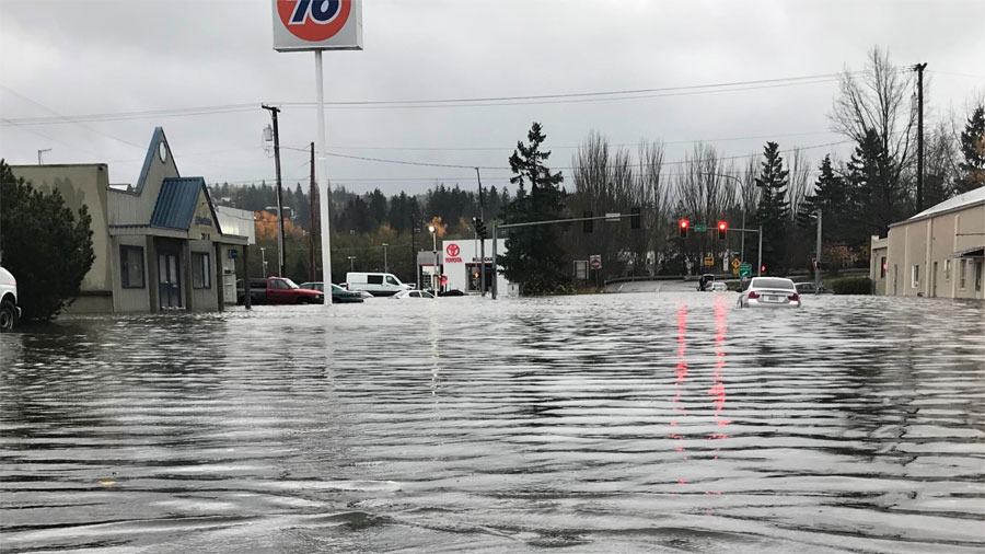


A second atmospheric river blew into the Western Washington region Monday morning, causing thousands of power outages, road closures, downed trees, mudslides, and severe flooding, especially in areas of Whatcom County.
Flood warnings continue Tuesday, damage across Western Washington
While most of the rain and winds have either stopped or significantly calmed down since their peaks mid-afternoon on Monday, people across the region are left dealing with fear that rivers will continue to rise and the messes left behind.
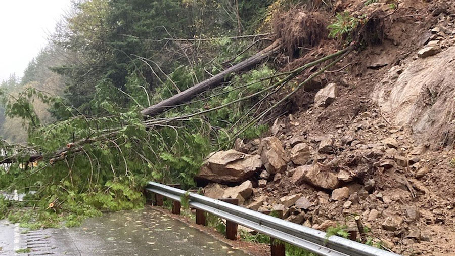
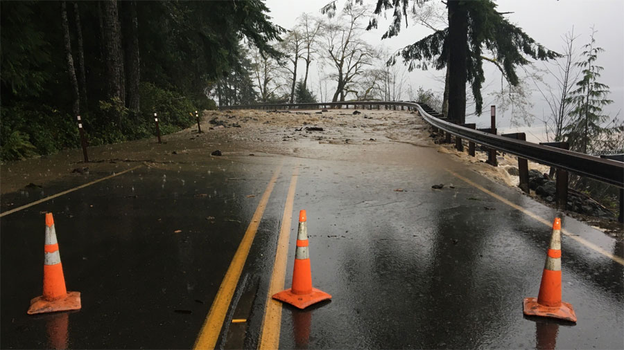
I-5 remains closed in both directions near Bellingham for a mudslide and the Elwha River bridge on Highway 101 into Port Angeles is closed — signifying the challenges people face just to get around.
Several school districts have already announced closures for Tuesday.
Forecasters say the weather for the rest of the week returns to normal for November, but that also means a return to cold temperatures.
Puget Sound Energy Outage Map
Seattle City Light
Snohomish County PUD Outage Map
5:52pm – Gov. Jay Inslee issued an emergency weather proclamation on Monday evening. That will help mobilize response efforts for areas most affected by heavy flooding and landslides. Read the full proclamation here.
5:47pm – Power outages have persisted across Western Washington into the evening. Puget Sound Energy reports roughly 87,000 impacted customers, while Snohomish County PUD reports 27,000 customers without power. Seattle City Light is dealing with just 18 active events, impacting an estimated 427 customers.
5:41pm – Both directions of I-5 in Whatcom County near Bellingham will remain closed overnight, according to WSDOT.
Both directions of I-5 in Bellingham will remain CLOSED overnight due to flooding & active slides threatening the highway. NB will be closed at Nulle Road (milepost 246) and SB at North Lake Samish (milepost 244). We will reassess in the AM. pic.twitter.com/9avZwHwquq
— WSDOT North (@wsdot_north) November 16, 2021
5:25pm – A Wind Advisory remains in effect until 7 p.m. for much of the Western Washington region, from Skagit County to Toledo. Wind gusts have considerably died down since peak speeds around 12 p.m.
4:51pm – Rainy conditions may have faded in the late afternoon, but for cities like Bellingham, it’s still an “all hands on deck” situation as workers respond to impacts from record-setting rainfall and flooding.
According to Bellingham officials, the city saw upwards of 4.5 inches of rain in just 36 hours, taking sewer pipes and pumping stations to capacity. That has city arborists responding to numerous downed trees, while crews work to clear blocked storm drains, and monitor sewer services and lake levels.
4:46pm – Rain and wind is quickly turning to snow in the mountain passes.
Snow on Hwy 2 Stevens pass, WA has started. More to come likely worsening road conditions this evening and overnight in that area on Hwy 2. By Tuesday morning, 6 to 9 inches could fall. If it's concentrated over the pass then possibly up to 15 inches. #wawx #winter pic.twitter.com/5F1ZDDoVTm
— NWS Spokane (@NWSSpokane) November 16, 2021
4:37pm – Reminder that the Sounder Train N Line (north) was completely canceled today for potential mudslides. Sound Transit says the S Line (south) will experience 10-minute delays. It later updated the alert to say that the 3:35 train out of Seattle was delayed 20 minutes for weather.
4:30pm – WSDOT says the Highway 101 Bridge over the Elwha River is completely closed until further notice. There’s no detour because of standing water or nearby mudslides. WSDOT crews will reopen the bridge once it’s safe.
🚧‼️The US 101 Elwha River Bridge near #PortAngeles remains CLOSED until further notice due to high waters.
There is no detour for this closure because there are also closures on SR 112 due to standing water or slides nearby. Our crews will reopen once it’s safe to do so. (1/2) pic.twitter.com/ULuaUh7umf— WSDOT Tacoma (@wsdot_tacoma) November 16, 2021
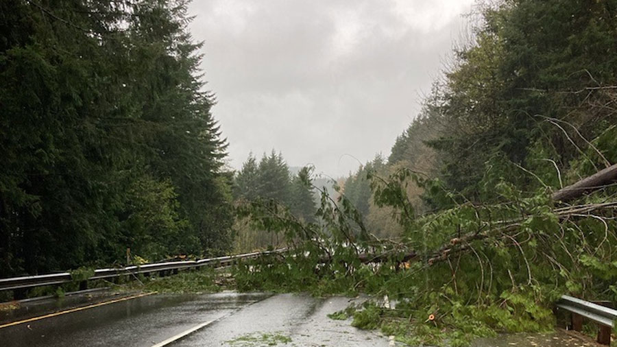
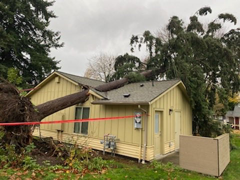
4:20pm – Valley Regional Fire says it has responded to five trees across roads or on homes today, and another 13 downed wires or other storm related issues.
Large tree blocking residential street at the 28100 block of 109th Ave SE in Auburn. Power is out in the area. pic.twitter.com/HEZi3Ir41t
— Valley Regional Fire (@ValleyFire) November 15, 2021
VRFA crews confirmed that no one was inside the home when this tree fell in north Auburn. pic.twitter.com/gk9wNKg2TC
— Valley Regional Fire (@ValleyFire) November 15, 2021
4:01pm – The National Weather Service is tracking high wind gusts across the state.
Here are a handful of highlights from Monday: Sea-Tac Airport – 58 mph at 9:40 am, Paine Field – 53 mph at 11:59 am, Bellingham Airport – 54 mph at 8:32 am, JBLM – 48 mph at 12:51 pm, Bremerton Airport – 40 mph at 7:23 am, Whidbey Island NAS – 63 mph at 1:01 pm, Hoquiam Airport – 60 mph at 11:06 am, New Dungeness Lighthouse – 62 mph at 12:08 pm.
Here's a gorgeous look at the satellite look as this system moved across the region today. #wawx pic.twitter.com/VmljctSs1u
— NWS Seattle (@NWSSeattle) November 15, 2021
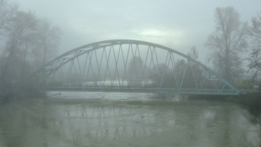
3:48pm – The National Weather Service says there are three rivers at four different locations that are in major flood stage:
– Bogachiel R. near La Push (cresting now)
– Nooksack R. @ N Cedarville (believed to be cresting now)
– Skagit R. near Concrete (already crested)
– Skagit R. near Mt. Vernon (will crest Tuesday afternoon)
3:42pm – Drivers should look out for several road closures brought on by flooding and landslides today. Those include:
Closures due to flooding/slides
State Route 546
EB/WB from Bender Road (MP 2.01) to Vinup Road.
EB/WB at Trapline Road (MP 6.05).
EB/WB at Van Buren Road.
State Route 547
•Eastbound and westbound from just south of Bishop Road (MP 8.2) to Telegraph Road, near Sumas (MP 8.9).— TracyTaylorTraffic 🚦 (@TracyTTraffic) November 15, 2021
3:16pm – All that moisture fell as snow in the mountains. Check for falling snow levels.
Snow levels are on their way down. Here's a 4 hour difference from the Crystal Mountain webcam. #wawx pic.twitter.com/qF3rXsfGsq
— NWS Seattle (@NWSSeattle) November 15, 2021
2:56pm – Trees are down on Valley Avenue in Fife, the Elwha Bridge on Highway 101 is closed, and a semi truck blocks SB I-5 near the Cowlitz River. That’s in addition to a mudslide along I-5 in Whatcom County at milepost 245 that is blocking all lanes. Drivers beware of downed trees and power lines, and standing water.
UPDATE: Unfortunately, another tree has fallen and is blocking Valley Avenue. Also, two more trees are leaning over the roadway. Crews are closing Valley Avenue again, this time from 58th to 62nd Avenue East. Please find alternate routes. Local access only. pic.twitter.com/FHDz8nEA4n
— Fife Police Dept. (@FifePD) November 15, 2021
There is currently no alternate route available drive west from Port Angeles due multiple slides, flooding and trees across roadways. https://t.co/SdrVkOaQAp
— KONP (@KONP1450) November 15, 2021
Due to a collision on SB I-5 at MP 59.1, near Exit 59/Cowlitz River, your Amazon delivery may be a little late, and so might you if you're stuck in the backup! Please slow down through the area & give crews room to safely clear the highway. Have patience and expect delays. pic.twitter.com/4Sv6JPEDwx
— WSDOT SW (@wsdot_sw) November 15, 2021
2:43pm – The National Weather Service says winds have peaked in most places today and will continue to dwindle into Tuesday. However, areas around Admiralty Inlet and the Strait of Juan de Fuca might experience gusts into the evening.
Time lapse of the convergence zone north of our office.
(and a lot of geese) #wawx pic.twitter.com/rSYAtitcc8
— NWS Seattle (@NWSSeattle) November 15, 2021
2:36pm – Semi-truck still blocking Deception Pass Bridge. WSDOT says to expect delays.
HAPPENING NOW: SR 20 fully blocked EB & WB from Cornet Bay Rd (MP 41) to Rosario Rd (MP 43) due to semitruck that has tipped onto the railing. Crews are onscene. Expect delays. (Photo: @eljavii10) https://t.co/GtVX6fmA3l
— WSDOT North (@wsdot_north) November 15, 2021
Scary situation on the Deception Pass bridge! #wawx #pnw #wind @NWSSeattle pic.twitter.com/hEi6rysAFb
— Benjamin Jurkovich (@BenjaminJurkovi) November 15, 2021
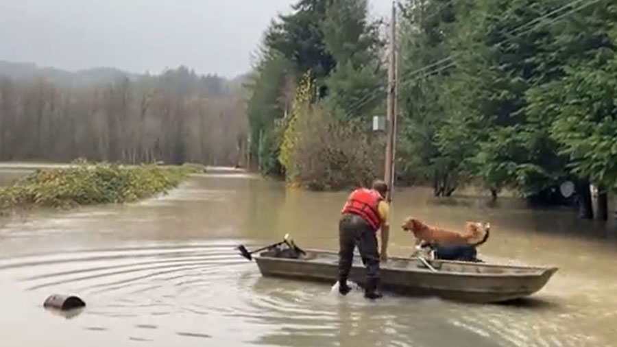
2:30pm – The U.S. Coast Guard says it has successfully rescued 10 people from flooded areas near Forks and Highway 110.
2:20pm – Thousands of people are without power after the storm front rolled through. There are 118,000 Puget Sound Energy customers without power, with most outages in the areas of Tacoma, Skagit County, and Chehalis. Another 16,000 Snohomish County PUD customers are without power, mostly in areas of Arlington, Camano Island, Granite Falls, and Lake Stevens. Another 800 Seattle City Light customers are without power.
2:12pm – Forecasters say a convergence zone is forming near the King-Snohomish County line. The Space Needle camera gives us a good visual of the difference in Seattle versus the North Sound.
Vivid view from the Space Needle of a convergence zone taking shape near the Snohomish/King county line. #wawx pic.twitter.com/mDCuVNntIZ
— NWS Seattle (@NWSSeattle) November 15, 2021
The surge of wind through the Strait of Juan de Fuca is morphing into a Puget Sound Convergence Zone. This is a look at the wall of rain moving toward our office. #wawx pic.twitter.com/pjOq378Y7w
— NWS Seattle (@NWSSeattle) November 15, 2021
1:56pm – A mudslide along I-5 in Whatcom County at milepost 245 has all northbound lanes blocked thanks to a tree in the road. There were no serious injuries reported, although three vehicles were damaged.
Thankfully no serious injuries. N5 MP245 in Whatcom. Three vehicles involved. https://t.co/Qf8iFXhDIc pic.twitter.com/EOIUbHnPFm
— Trooper Rocky Oliphant (@wspd7pio) November 15, 2021
Meanwhile, a semi-truck is tipped over and leaning on a Deception Pass Bridge railing, blocking all northbound traffic off Whidbey Island. State patrol says the driver is out and OK, and a tow truck is on the way.
1:35pm – Road crews across the region are dealing with downed trees and power lines, and standing water. Check your route if you have to drive and expect delays.
Pioneer Highway is currently CLOSED between 86th Drive and Nordic Way due to fallen trees. PUD has been informed. Please avoid this area and use extreme caution while traveling the roads. pic.twitter.com/pbNddnj8Kp
— City of Stanwood (@CityofStanwood) November 15, 2021
1:30pm – While rain has died down in several areas, KIRO 7 meteorologist Claire Anderson warns that windy conditions are expected to persist through the evening, with gusts as high as nearly 60 miles an hour near Whidbey Island, and around 40-50 miles an hour near Seattle and Tacoma.
Strong winds today with wind gusts up to 60 mph possible for the Admiralty Inlet Area. Expected gusty conditions through this evening. @kiro7seattle #kiro7seattle #seattle #wawx pic.twitter.com/oapLlKMh3f
— Claire Anderson (@ClaireKIRO7) November 15, 2021
1:12pm – Reports of sun in areas of North and West Seattle. However, the temperatures are expected to drop in Seattle and the South Sound. Already, the National Weather Service said temperatures dropped by 9 degrees in 20 minutes across Everett as the front passed through.
1:01pm – The Whatcom County Sheriff’s Office has crews out rescuing drivers stuck in standing water. Again, officials are warning people to avoid standing water if possible.
RESCUE OPERATION UNDERWAY. A look at the current conditions in the Everson area as deputies evacuate stranded residents in WCSO's rescue vehicle. pic.twitter.com/rOoIHifyh1
— Whatcom County Sheriff's Office (@whatcomsheriff) November 15, 2021
12:50pm – The U.S. Coast Guard is evacuating people out of Forks on Monday, according to KIRO 7. People west of Forks, near Highway 110, were in danger from rising flood water. KIRO 7 reports at least 10 people are affected.
12:44pm – River update via the National Weather Service:
Nooksack R. at Everson appears to be cresting. This is the water flowing into the Sumas area.
Nooksack R. at Ferndale will likely crest during Tuesday.
The Calawah R. near Forks has crested and is beginning to recede.
The Bogachiel R. near La Push will likely crest in the next 1-3hrs.
The Elwha R. at McDonald Bridge will likely crest in the next 1-3hrs.
Skagit R. at Concrete appears to be cresting.
Skagit R. near Mt Vernon will crest tomorrow and may be near record stage.
Samish R. near Burlington appears to have crested.
12:36pm – Messy landslides near Forks. Crews are working to clean those up.
#Forks: Here is a look at one of the three slides along US 101 near milepost 186 in Clallam County. Please do not go beyond road closures. Our crews are actively clearing debris and will reopen roads as it's safe to do so. pic.twitter.com/iXPpozgeoJ
— WSDOT Tacoma (@wsdot_tacoma) November 15, 2021
12:27pm – KIRO 7 Meteorologist Morgan Palmer found a perfect illustration of where the warm, wet weather is coming from. Aloha, rain and wind.
See the direct moisture connection to Hawaii. #pineappleexpress #atmosphericriver #wawx https://t.co/WnUNDTWNJG
— Morgan Palmer (@MorganKIRO7) November 15, 2021
12:23pm – Special weather statement issued for the Lake Stevens, Granite Falls, Arlington, and Concrete areas until 1:15 p.m. Seek shelter in a sturdy structure.
A special weather statement has been issued for Lake Stevens WA, Arlington WA, Granite Falls WA until 1:15 PM PST pic.twitter.com/imInAIHMKh
— NWS Seattle (@NWSSeattle) November 15, 2021
12:10pm – People in the Sumas and Bellingham regions are asked to avoid driving if possible and certainly avoid driving through standing water.
Iowa Street, near all the Car Lots. Bellingham, WA. 11/15/21 via Travis Janeway pic.twitter.com/BCVydgTusr
— Breaking Skagit (@BreakingSkagit) November 15, 2021
11:57am – It’s a rough day at sea with a High Wind Warning in effect until 7 p.m. Several runs on Washington State Ferries have been canceled or delayed due to the weather. Additionally, the Hood Canal Bridge temporarily closed from 11:08 a.m. to 11:44 a.m.
Check with WSDOT for updated information on ferry schedules and changes here.
In case you're wondering what conditions are like aboard our vessels right now. Thank you to our crewmembers braving the weather… please follow all their instructions for your safety. Our captains make the call whether it's safe to sail. https://t.co/OXrN4XJfIh
— Washington State Ferries (@wsferries) November 15, 2021
11:53am – Again, road crews are reminding drivers to use extreme caution and to expect delays as they clear downed trees and power lines.
🌲Lots of trees down & caught in power lines throughout the region. All of our amazing crews are out in full storm response. 💯🦺
Photos: #Vashon (Westside Hwy/Madrona Rd; Dilworth Rd./Shanahan Rd. #wawx #KingCountyReady @VMIBeachcomber @VoiceofVashon1 pic.twitter.com/QWdT803Wx3— KC Road Services (@kcroads) November 15, 2021
11:49am – The National Weather Service reports a 99 mph gust on Mount Rainier (6880 feet in elevation) — wind speeds at 67 mph.
11:47am – Drivers are warned to use caution during the storm. Downed trees and power lines have closed off several main roads and back streets.
The Eastbound lane of SE 312th in Auburn partially blocked by tree debris. Please avoid the area while VRFA crews remove the tree. pic.twitter.com/VR5M7wSh7u
— Valley Regional Fire (@ValleyFire) November 15, 2021
11:37am – The mayor of Mount Vernon has declared a state of emergency due to flooding, KIRO 7 reports. Three riverfront parks are closed and a flood wall was deployed. The city anticipates closing the Highway 538 bridge if the river reaches 35 feet at the Riverside Gauge, according to KIRO 7.
The mayor is urging residents to prepare their homes and businesses for widespread flooding.
Contact Skagit County Department of Emergency Management at 360-416-1850 for sandbags and other resources.
11:39am – The National Weather Service says four rivers have reached record levels during this recent flood event: Nooksack River at Cedarville, Samish River at Burlington, Bogachiel River near La Push, and the Calawah River near Forks.
11:35am – Parks and trails are closed in Puyallup, according to police. They’ll reopen once it’s safe for visitors.
ALL City Parks and Trails are closed due to high winds. Park Staff will assess the safety of the parks and trails once the weather subsides and will notify when its safe to reopen them. Please stay safe! pic.twitter.com/hMZCTheovq
— Puyallup Police (@PuyallupPD) November 15, 2021
11:20am – The front is making its way to Whidbey Island, according to the NWS.
Here's a view of the surge in the strait as it approaches Port Townsend and Whidbey Island as seen in velocity data from our radar on Camano Island. #wawx pic.twitter.com/ukVkHTZJ0n
— NWS Seattle (@NWSSeattle) November 15, 2021
11:05am – Strong winds out on the coast. Port Townsend is expected to see strong gusts, according to the NWS.
Westerly surge has reached the Sequim area. New Dungeness lighthouse reports sustained wind westerly at 40 mph. #wawx
— NWS Seattle (@NWSSeattle) November 15, 2021
10:51am – Snoqualmie Valley Road is closed for major flooding.
⛔️🌊Here are 2 photos of NE 124th near W. Snoqualmie Valley Road (Nov. 13, 2021). This section will prolly stay closed for a while. Find out what else is closed/open👉🏽https://t.co/EunWWcnwA0👈🏽 #SnoqualmieRiverValley #wawx @KCDNRP #TurnAroundDontDrown pic.twitter.com/KokzpcebXA
— KC Road Services (@kcroads) November 15, 2021
10:34am – Stronger winds and colder temperatures are on the way.
The cold front has now made its way through the coastline of Jefferson County and will be moving through the coast of Grays Harbor County over the ~1hr. Strongest winds are expected ahead of the front in this area. Temperatures will fall quickly behind the front. #wawx pic.twitter.com/EiVbbfTKqm
— NWS Seattle (@NWSSeattle) November 15, 2021
10:26am – Road closures across Whatcom County, too. WSDOT says reopening a road is more than just clearing debris. It also means making sure that the nearby hillside is stable.
Here's some photos from the scene on northbound I-5 at Nulle Rd. in #Bellingham where all lanes are blocked. Maintenance and WSP are on scene, no timeline on reopening. https://t.co/xcU4nSm7aB pic.twitter.com/0hRUGie2JY
— WSDOT Traffic (@wsdot_traffic) November 15, 2021
10:23am – Several roads are closed just across King County duty to flooding, and downed trees and power lines. Stay up to date here.
10:10am – About 40,000 PSE customers are without power. Another 400 Snohomish County PUD customers have no power.
10:03am – 58 mph gust clocked at Sea-Tac!
In the last few minutes, Sea-Tac airport had a wind gust to 58 mph. The next several hours through 6 or 7 PM will be the windiest around Puget Sound with gusts of 40 to 50 mph common. #wawx
— NWS Seattle (@NWSSeattle) November 15, 2021
10:00am – Extensive flooding in and around the Sumas area. Several roads are closed.
Current conditions on Cherry St in Sumas. Road closed to Canadian Border pic.twitter.com/bN09N8Q2rk
— Sumas Police (@SumasPolice) November 15, 2021
9:54am – Get ready, Seabrook. The National Weather Service says it’s about to get gusty until about noon.
The front is about to reach the central coast. Look for a sudden wind shift to west/southwest and damaging wind gusts up to 60-65 mph to occur in the next 30 to 90 minutes. #wawx pic.twitter.com/i2oVN5pDZq
— NWS Seattle (@NWSSeattle) November 15, 2021
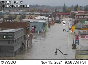
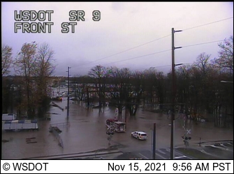
9:41am – Neighborhoods in Whatcom County are under several inches of water.
Waters still rising in Whatcom County. #wawx https://t.co/cknb7qdXl4
— NWS Seattle (@NWSSeattle) November 15, 2021
9:32am – A Wind Advisory is in effect for areas along the I-5 corridor from Seattle south to the state border, and most of Kitsap County. Expect sustained winds from 15-30 mph and gusts up to 45 mph until at least 4 p.m. There’s also a High Wind Warning in the Admiralty Inlet area with gusts up to 60 mph until at least 7 p.m.
9:07am – Check out the peak wind speeds from the National Weather Service. We know of someone who lost two umbrellas to the wind gusts this morning.
900am: Some of the peak winds over the past hour –>
– 58 MPH Hoquiam
– 55 MPH Olympia
– 54 MPH Bellingham
– 47 MPH Tacoma
– 46 MPH Quilayutte
– 45 MPH Seattle (SeaTac)
– 43 MPH Everett Paine Field#wawx— NWS Seattle (@NWSSeattle) November 15, 2021
Follow @http://twitter.com/Mynorthwest