All Over The Map: 1970s nautical atlas still a Northwest gem
Jul 22, 2022, 7:11 AM | Updated: Oct 25, 2022, 4:20 pm

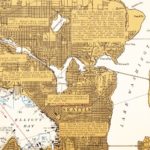
The page for Seattle, as seen in the "Exploring Puget Sound & British Columbia" marine atlas, includes place-name and other historical information not found on government charts. (Evergreen Pacific Publishing)
(Evergreen Pacific Publishing)
Back in the 1970s, a young couple compiled a unique marine atlas of Northwest waters. The book is still in print, and it still stands out from similar navigation books published over the years for recreational boaters in Washington and British Columbia.
To safely navigate inland waters, big ships and other vessels helmed by professional mariners use nautical charts produced by the government in the U.S. and Canada. Charts – the proper name for maritime maps – show geographic features, depth of the water, location of buoys and lights, and sometimes course headings for routes between particular ports – all the information a mariner needs need to not run aground or otherwise get into trouble on the water. One drawback is that nautical charts are often pretty big, perhaps three feet across and two-and-a-half feet from top to bottom. On big ships, navigators use a large chart table to view charts properly. Those charts may be big, and they’re also expensive.
This week on “ALL OVER THE MAP”
Maritime atlases – govt nautical charts in book format for small boats – first appeared in the NW in the 1950s.In 1975, “Exploring Puget Sound & British Columbia” was a little different: combining charts and history to make a unique resource. pic.twitter.com/mawlbmQib2
— Feliks Banel (@FeliksBanel) July 22, 2022
To solve the size and cost problem, publishers around here back in the 1950s started producing marine atlases – wire or comb-bound booklets of charts that were cheaper and smaller, and thus more accessible to recreational boaters and easier to use on a small boat.
In the early 1970s, Stephen and Linda Hilson bought a boat – a 40-foot, 1938 Edwin Monk wooden boat named SASSY II – which they took cruising along the California coast. The young couple didn’t know much about boating, but they learned in a hurry. They also got help from a lot of nice people along the way and, on at least one occasion, were aided by the Coast Guard when they got into serious trouble.
Stephen Hilson was from Lansing, Michigan and Linda Hilson George grew up in Portland, Oregon, and neither had spent much time in coastal waters. The two had met in Chicago in the late 1960s when they were both a part of a Christian musical group called the Spurrlows.
“We traveled all over the country and sang for dealer openings, we were sponsored by Chrysler Motors,” said Linda Hilson George, one-half of the couple who created the atlas. “We did high school shows, safe driving shows, and all the pop music. And then on the weekends, we did two-hour contemporary Christian concerts.”
“That was pretty fabulous,” Hilson George said.
After one particularly rough storm off the coast of California, the pair ultimately had the SASSY II trucked from San Francisco to Seattle rather than risk a cruise up the Oregon Coast. It was on a subsequent voyage from Seattle to Alaska where the idea was hatched for their own take on a marine atlas. “Exploring Puget Sound & British Columbia” was released in 1975 by Van Winkle Publishing in Holland, Michigan.
“I think we planned the trip first, and then the book was something we decided to do along the way,” said Linda Hilson George. “It was just really fun trying to figure out how to get from the proper place – from Point A to Point B, [and] where they would have everything that we needed.”
“It wasn’t always clear” how to do that, especially for novice mariners, “and so we took care of that for other people making the trip,” Hilson George said.
The Hilson’s atlas has dozens of pages of reproductions of government nautical charts, and it also shows the places boaters can get fuel and groceries, get engine repairs or other maintenance work done, or tie up at a temporary moorage.
The charts and information about services made, “Exploring Puget Sound & British Columbia” were not dissimilar to other marine atlases covering Northwest waters published in the 1950s and 1960s. What made the Hilson’s atlas unique is that Steve and Linda also included a ton of historic information on nearly every page – about place-names, early explorers, Indigenous history, shipwrecks, geology and other interesting facts about the waterways, the islands and the mainland.
They compiled this place-name research and other historic information from many different books and archives, and then used the blank spots on the reproductions of official charts – mostly land areas, which are often blank on nautical charts – to include short sentences and even lengthy paragraphs about the history of the cruising areas.
“Some of [the research] was done in Sitka at Sheldon Jackson College, and some of it was done in the Captain Cook and [Captain] Vancouver Special Collections at the University of Washington,” Hilson George said.
Linda and Steve parted ways many decades ago, and then Steve died in his 30s of lymphoma in 1983. Steve’s brother Birton Hilson was involved with production and distribution of the first edition, and he later assisted with a slightly updated edition, published by Evergreen Pacific in Everett in 1996, and then reprinted in 2001.
A spokesperson for Evergreen Pacific says the company has sold more than 3,000 copies of the 1996 and 2001 printings of the book, and that they intend to keep “Exploring Puget Sound & British Columbia” (as well as a companion volume for British Columbia and Alaskan waters) in print.
Linda Hilson George lives in Michigan nowadays, thousands of miles from Puget Sound, but she clearly has fond memories of the time spent working with Steve Hilson on the atlas. Did she become super wealthy from helping produce “Exploring Puget Sound & British Columbia” nearly 50 years ago?
“Not quite, no,” Hilson George said, laughing. “It was a labor of love, really. And it was just, I don’t know . . . we were pretty proud of ourselves.”
“It was the greatest adventure ever,” she said.
You can hear Feliks every Wednesday and Friday morning on Seattle’s Morning News with Dave Ross and Colleen O’Brien, read more from him here, and subscribe to The Resident Historian Podcast here. If you have a story idea, please email Feliks here.

