WSDOT plans for Carbon River Bridge expected to take two more years to complete
Jan 11, 2026, 10:17 AM
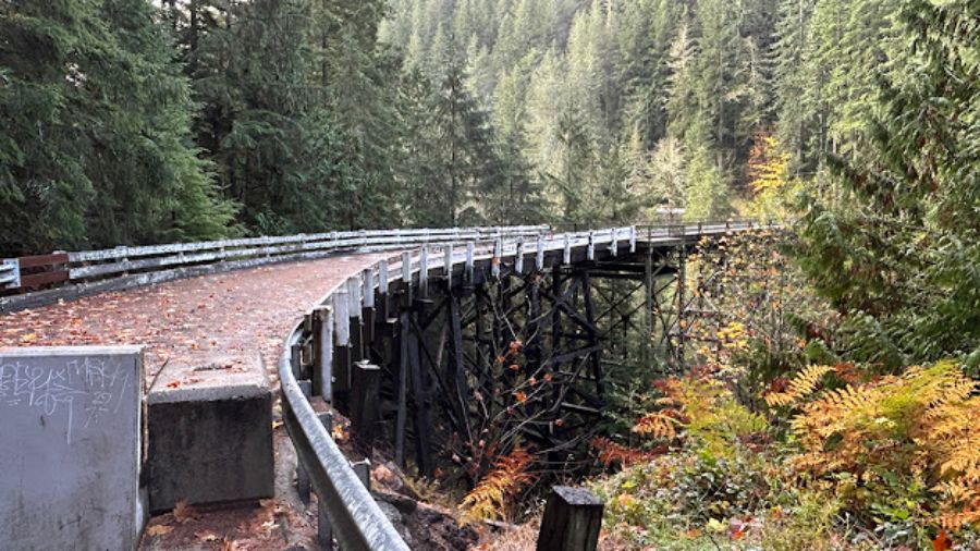
State officials expect an environmental review for the possible replacement of the Carbon River Bridge will take two more years to complete. (Photo: Washington Dept. of Transportation)
(Photo: Washington Dept. of Transportation)

The future is still uncertain for a bridge that was once the lifeline for people living and working in the towns of Carbonado and Wilkeson, near Mt. Rainier.
State officials say a federally-required environmental study of a possible replacement for the Carbon River Bridge will likely take another two years.
That’s bad news for residents and businesses in those towns who relied on the bridge for transportation and to bring in customers.
State officials say it will take from six to twelve months to gather information about geological formations in the area.
They are also working on getting right-of-way permits from land owners and environmental clearances before work can begin.

This is one of the spots being considered for a new Carbon River Bridge above the canyon, just north of the existing bridge. (Photo: Washington Dept. of Transportation)
Since the bridge was built in the middle of thick forest with steep terrain, it’s technically-challenging and difficult to place a drill rig to take coring samples. Work will be necessary to find out if the ground is strong enough to construct a bridge foundation.
In addition, a federal law passed in 1970, known as the National Evironmental Policy Act, requires potential environmental effects to be considered.
That information will be used to determine whether permit applications will be approved to build a new roadway and bridge.
On Thursday, the Washington Department of Transportation posted a lengthy blog describing the process for determining future plans for the bridge:
To help guide a long-term vision, we do what’s called a planning study. Think of it like a road map. It’s a deep dive into an issue where we can look at many different options and measure the costs of those options. We put a lot of work into moving this study along as fast as we could. We evaluated options that addressed access across the Carbon River Canyon.”
— Washington State Dept. of Transportation
The 104-year-old bridge across the Carbon River Canyon on State Route 165 closed nine months ago, after engineers discovered one of its support columns was bent and buckling.
Inspectors also determined there was also severe deterioration in several spots on steel plates called gussets, that are used to connect the bridge’s trusses and wooden support beams.
The difficult decision to close the bridge left residents south of the span with no way to cross the Carbon River Canyon.

The state placed a permanent barrier in front of the SR 165 Carbon River Bridge, following the closure nine months ago. (Photo: Washington Dept. of Transportation)
Officials have created a temporary bypass route, but say it’s not a long-term solution.
Since closing the bridge, transportation officials have completed a planning study on a possible bridge replacement.
In a blog posted last week, WSDOT identified three options.
They include demolition of the current structure and building a new bridge at the same location, re-routing the bridge in a new spot east or west of the canyon, or not replacing the bridge at all and closing the highway.
Back in May and June, WSDOT held two open house events and also invited comments online.
They received more than 2,800 comments.
The option of a permanent closure was the least preferred by those who shared their views.
In August, officials invited more comments at another community meeting. They also shared the alternatives that seem most likely to take place after the initial planning study.
One is replacing the bridge just north of the existing location.
The other is not building a new bridge at all, and simply closing the highway.
An environmental review will also take into account the historical significance of the aging span.
According to state officials, Section 106 of the National Historic Preservation Act outlines a national policy for the protection of historic structures, to preserve the nation’s heritage.
Since SR 165 Carbon River Bridge is listed in the National Register of Historic Places, those policies will have to be followed as the state plans for the future.
The department has also set aside $7 million in preservation funding from the 2025-27 biennium Transportation Budget to begin the process of moving from the planning study to design work and the environmental review.
Since the closure, transportation officials have taken steps to give those who live south of the bridge a usable roadway to get to and from Carbonado and Wilkeson.
The blog described how private property owners have given permission to use their land:
This meant issuing keys to a privately owned bypass route. This nine-mile route is not open to the general public. It’s a winding, narrow, gated gravel logging road that we don’t own. The route is owned by five private property owners, as are the gates at either end of the route. We negotiated emergency permits and rights of entry with each property owner so people living south of the bridge had a way to get to and from their homes across the Carbon River. This route was established in late summer 2024 when the bridge was severely weight-restricted. We appreciate the willingness of the bypass route’s five property owners to work with us on this issue.”
Transportation officials have also signed an agreement with the Department of Commerce to help pay for automatic gates on the bypass route, which will be installed in the near future.