
Rain to ease midweek before returning as atmospheric river shifts through region
Dec 9, 2025, 5:02 AM | Updated: 4:12 pm
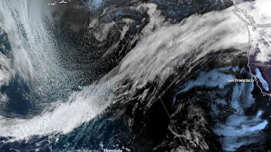
This image from Zoom Earth shows the path of the atmospheric river as it flows through the North Pacific Ocean to western Washington. (Image courtesy of Zoom Earth)
(Image courtesy of Zoom Earth)
This week is going to be a mild, wet one. An atmospheric river that sent a surge of rain into western Washington Monday is now sagging south toward Northwest Oregon. It will then pivot north again Tuesday night and Wednesday.
An atmospheric river is a stream of moisture from tropical or sub-tropical sources transported into mid-latitude storm systems, and produces copious amounts of rainfall with relatively high snow levels. This feature is actually quite common around the globe and helps produce the bulk of mid-latitude annual rainfall, including the Pacific Northwest.
How much rain?
Forecast rainfall amounts through Wednesday are indicative of a soggy atmospheric river. The Cascades will receive the greatest amount of rain, ranging from 6 to 12 inches of rain. The Olympics will also retain its rain forest reputation with 5 to 10 inches expected.
The coast and southwest interior are anticipated to receive 2 to 4 inches of rain through Wednesday, while areas from about Seattle northward will get the benefit of the Olympic Mountain rain shadow, reducing rain amounts to about a half to one and a half inches of rain.
Atmospheric river events bring warm, moist air, resulting in elevated mountain snow levels. On Monday, the snow level is expected to rise as high as 7000 feet. With the system sagging south into Northwest Oregon on Tuesday, snow levels are anticipated to drop to around 4,000 feet.
On Tuesday night and Wednesday, as the stream of warm moisture pivots back north, snow levels are forecast to rise again, this time close to 6000 feet. With so little current mountain snow, the heavy amounts of rainfall are quite likely to simply run into rivers and streams.
Impacts – flooding, winds, King Tides, landslides
The last time this kind of heavy rainfall fell was back in November 2022. The most serious flooding was in the North Sound, primarily in Whatcom County.
This atmospheric rain event will create more widespread flooding in western Washington. Rivers from near the Canadian border to the Columbia River are anticipated to exceed flood stage starting either Monday night or Tuesday.
The most serious flooding is anticipated with rivers flowing out of the Cascades, including the Skagit, Stillaguamish, Skykomish, Snoqualmie, Tolt, Snohomish, Puyallup, Carbon, Nisqually, Chehalis, Skookumchuck, Newaukum, and Cowlitz rivers.
If you live in or have just moved into a flood-prone or low-lying area, there are steps to take ahead of the flood. Some resources include the Washington State Emergency Management Division flood preparedness website, FEMA’s flood readiness website, and your local county emergency management websites.
Those who commute through these low-lying flood-prone areas may also find roads closed due to high water. Follow the detours. Remember, turn around, don’t drown.
In addition, many other roadways may have standing water during heavy rainfall. When driving, slow down, avoid hydroplaning, and leave plenty of distance behind the vehicle in front of you.
Winds
Winds can be another impactful factor this week. As each surge of rain with this system moves onshore, southerly winds are likely to pick up with gusts up to 30 to 40 mph at times. Local downed trees or limbs, and power outages are possible.
King Tides
This month’s King Tides period peaked over this past weekend, yet high tides remain relatively high, and minor tidal overflow flooding remains possible in low-lying areas into Wednesday.
Landslide threat
The calendar year has been a dry one. Through this past weekend, Seattle-Tacoma International Airport (SEA) was more than 8 inches of rain behind for the year. This period of rainfall, though, will moisten up upper soil layers on steep slopes and make them prone to landslides over the drier, deeper soil layers.
RELATED STORIES


What’s ahead
This atmospheric river is expected to taper off starting Wednesday. Rain remains in the forecast heading into the coming weekend, but not fueled by sub-tropical moisture. Yet, it will take a period of time for the rivers to recede back below flood stage.
The latest weather outlook as the calendar approaches the Christmas holiday continues to reflect warmer and wetter than average conditions.
As always during flood season, remain vigilant and prepared in case of significant flooding, not only for your home or business, but also for your commute if it takes you through river basins.
Ted Buehner is the KIRO Newsradio meteorologist. Follow him on X and Bluesky. Read more of his stories here.













