
Remembering the Oso landslide: 43 lives lost 12 years ago
Mar 22, 2026, 5:00 AM

Trees lay on a hillside in the aftermath of a mudslide and related flooding on March 25, 2014 in Oso, Washington. (Photo: David Ryder via Getty Images)
(Photo: David Ryder via Getty Images)
March 22 marks a solemn day in Washington’s history. It was 12 years ago when the Oso/State Route 530 landslide occurred in Snohomish County. Forty-three lives were lost in this tragic event, the deadliest landslide in American history.
What happened
It was a Saturday morning. The sun was peeking through the clouds, offering a pleasant early spring day. The North Fork of the Stillaguamish River was receding in the wake of three days of dry weather following a wet winter.
Then, just past 10:30 a.m., a large segment of a hillside just north of the river gave way, surging across the valley just east of Oso in less than 60 seconds, sweeping away everything in its path, including the Steelhead neighborhood.
To this day, it remains unclear what triggered the massive slide. Was it the river nibbling at the foot of the hillside? Was it the weight of all the winter rainfall soaked into the hillside? Were other factors involved? Geologically, going back centuries, similar landslides had occurred in the valley. Rescuers moved in quickly to help pull those alive out of the massive debris.
The landslide temporarily blocked the river. Water in the river backed up, flooding homes just upstream of the slide area.
As that day wore on, concerns about the landslide blocked river steadily rose, raising theories about the blockage suddenly giving way and producing a flash flood-like surge of water downstream. There were some authorities and downstream communities who felt it was imperative to evacuate from the threat of flash flooding in Arlington and downstream into Stanwood, and adversely impacting the I-5 bridge over the Stillaguamish River.
At the time, I was the Warning Coordination Meteorologist with the National Weather Service (NWS) in Seattle, a key liaison position with the emergency management community. Joining our NWS Seattle team on duty that day, we collaborated throughout the day with the NWS River Forecast Center (RFC) in Portland on what are called dam break scenarios.
The RFC conducted several scenarios throughout the day as the situation evolved and found that when water managed to create a gap in the landslide blockage, the threat of downstream flash flooding was quite low.
The emergency manager for Snohomish County at the time, John Pennington, called late that afternoon to ask whether he should authorize activating the Emergency Alert System (EAS) to evacuate downstream communities and close the I-5 bridge as a result of the potential for flash flooding.
Given the NWS information collected throughout the day, he was advised of the dam break scenario results and chose not to activate EAS.
That decision turned out to be wise. Late in the day, water in the river did manage to create and flow smoothly through a gap in the landslide debris, easing fears of flash flooding downstream.
During the initial response and 6-week recovery efforts at the scene, spring showers and even a few thunderstorms hampered crews at work. Yet, response crews and their support teams did a monumental job with the recovery of those lost.
In September of that year, rebuilding State Route 530 through the devastated area was completed and fully reopened, and a roadside memorial was put in place near the landslide site.
RELATED STORIES

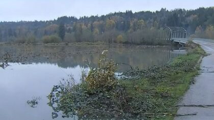

Looking at today
Ten years after the tragic event in 2024, a permanent memorial was dedicated, commemorating the 43 victims. The memorial has exhibits for visitors that honor the victims, survivors, and those who responded to the catastrophic event, serving to educate visitors about the disaster.
On Saturday, March 22, let’s remember and honor those who lost their lives on this date 12 years ago.
Ted Buehner is the KIRO Newsradio meteorologist. Follow him on X and Bluesky. Read more of his stories here.













