
All Over The Map: When the numbers came up for the Seattle waterfront
Apr 30, 2021, 7:56 AM | Updated: 9:03 am

In the middle of World War II – 77 years ago this week – the Port of Seattle re-numbered all the wharves and piers on the city’s busy wartime waterfront.
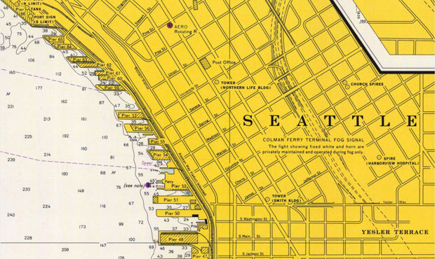
While those numbers on the piers, such as long-gone Pier 48 where Northwest Bookfest was held in the 1990s, or Ivar’s iconic home at Pier 54, can feel even to locals like they’ve been attached to those places since the dawn of time, they do only date back to May 1, 1944.
That was when a new system was adopted, with numbers from 24 to 91 applied to wharves, docks, and piers from south to north along what is sometimes still called the Central Waterfront. The numbers replaced what had been something of a hodgepodge of structures jutting out over the water and named for the businesses that owned or operated them – such as Whiz Fish Products, or Isaacson Iron Works, or Leslie Salt Company – or for the adjacent city street – like the Bell Street Terminal, which still retains most of that name, even though it also became “Pier 66” nearly 80 years ago. This random mix of business and street names probably wasn’t an ideal way to organize a busy center that residents and visitors counted on for commerce and passenger travel.
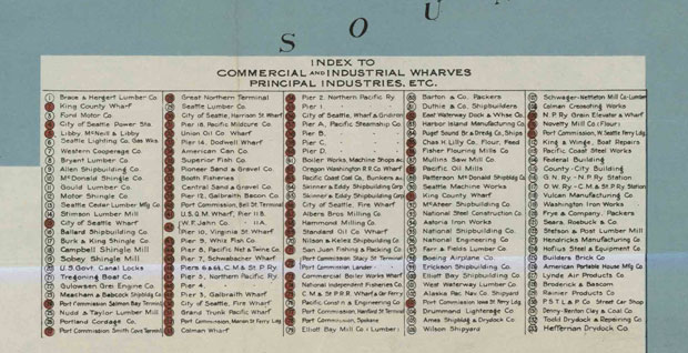
A Port of Seattle map published in 1918 shows the names of most of the old wharves and piers, and it’s a fun list of old Seattle companies and steamship lines from a time when the waterfront was all business. The 1918 map also shows that there was an earlier series of numbered piers in the middle of the Central Waterfront (which must have only added to the confusion). Other sub-numbering systems existed in 1918, too, such as Pacific Steamship’s four piers, lettered A through D (which in 1941 became Piers 49 through 46, in reverse order). A similar arrangement was created in the early years of World War II, when the military had four piers serving as the Seattle Port of Embarkation – for transporting soldiers and sailors. Those piers, also lettered A through D, became Piers 36 through 39.
In the 1944 system, numbers below 24 were reserved for the Duwamish Waterway and West Seattle – and the Port of Seattle eventually did use most of those. The numbered piers at the mouth of the river curl around Harbor Island in counter-clockwise direction and then reverse direction moving west – all the way down to Pier 2. Numbers above 91 were reserved for the Lake Washington Ship Canal, Lake Union and Lake Washington, but it appears that no piers were ever numbered this (or any other way) in those places.
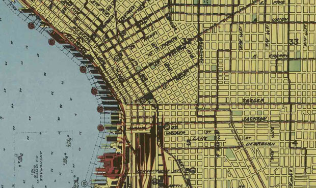
The Port of Seattle as a public entity was created in 1911, and it took decades for them to purchase and gain control of what had been railroad and steamship company-owned docks on Elliott Bay. In earlier decades, and going back to the mid-19th century, Seattle’s waterfront was the center of the city’s growth, and the place where Indigenous people, settlers, military, business and labor often struggled over how the modern city would gradually take shape. It was at times a chaotic place that quickly reflected, perhaps more than any part of the region, the cycles of economic boom and bust of those years – from gold rushes to wartime to financial panic and back again.
It’s no surprise that the new numbering system came during World War II, when the waterfront was booming again after the Great Depression, and tons of military supplies and thousands of soldiers and sailors were moving through Seattle. Newspaper accounts from the time indicate that the military – who essentially controlled the harbor during the war – saw the need to make the pier system easier to navigate and also had the authority to make the change with a minimum of public process. Those same newspaper accounts say that the move was approved by business owners, railroads, and most steamship operators, though Alaska Steamship Company objected to the renumbering of their piers – Pier 1 and Pier 2 – to the far less important sounding Pier 50 and Pier 51.
Subsequent newspaper clippings seem to indicate that the new numbers had caught on, at least in official circles, by the late 1940s. However, chances are that there were probably some crusty old sea dogs who never stopped calling their favorite spots the Grand Trunk Pacific Wharf, or the Dodwell Wharf, or the Union Pacific Dock – or maybe even just good ol’ Pier 1 and Pier 2.
You can hear Feliks every Wednesday and Friday morning on Seattle’s Morning News, read more from him here, and subscribe to The Resident Historian Podcast here. If you have a story idea, please email Feliks here.


