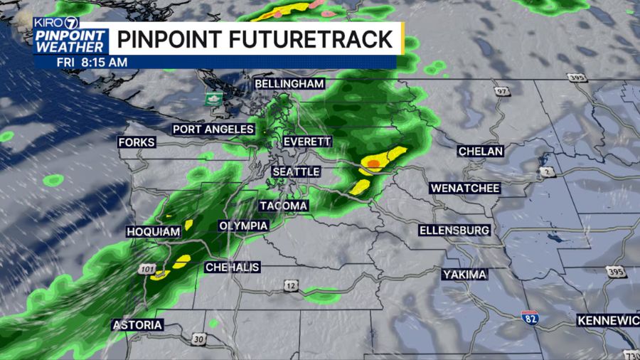
‘Godzilla atmospheric river’ targets Seattle area with major flooding and landslide threats
Dec 5, 2025, 8:07 AM | Updated: 5:09 pm
Western Washington residents have this weekend to prepare for what forecasters are calling one of the strongest atmospheric river storms in years. The “Godzilla atmospheric river” system, as meteorologist Cliff Mass calls it, may bring major flooding, landslide dangers, and a month’s worth of rain compressed into just days, with the worst conditions arriving Tuesday.
The Pacific Northwest is bracing for one of the most powerful atmospheric river storms in recent memory, with forecasters now predicting a Category 5 event that could bring widespread flooding and dangerous landslides to Western Washington next week.
“It’s definitely going to be a strong storm,” meteorologist Scott Sistek told Seattle’s Morning News on KIRO Newsradio Friday morning. “It’s definitely going to be one of the stronger ones we’ve seen in recent years, but it’s not going to be a record. It’s definitely one to be ready for.”
RELATED STORIES
Category 5 rating signals serious danger
The Center for Western Weather and Water Extremes, which tracks atmospheric river systems, has upgraded its forecast to Category 5, the highest level on its scale.
“While not on par with an extreme rating like a Category 5 hurricane or an EF-5 tornado, a Category 5 atmospheric river means that the storms are inherently hazardous to the region with potential for major river flooding,” Sistek explained in his blog, Emerald City Weather.
Sistek noted that Category 5 atmospheric rivers are rare, but not unprecedented.
“It’s probably more like a frequency about every other year, every three, four, five years,” he said.
Multiple waves of storms
“Essentially multiple storms coming in succession, with more Friday, Sunday, and then the larger atmospheric river storm Monday through Wednesday,” Sistek wrote. “The Friday and Sunday storms are wet (wetter than Thursday) but not impactful yet. Mostly, they are just playing the role of starting to fill the rivers so that they’re already straining when the strongest storm(s) of the bunch come in next week.”
The main atmospheric river event will arrive in two waves.
“The first one’s kind of Monday into like Monday night, early Tuesday, maybe like a little bit of a let up Tuesday morning, and then the second wave comes in Tuesday afternoon through the night into Wednesday,” Sistek told Seattle’s Morning News.
Extreme rainfall totals expected
“We’re talking about five or six inches of rain,” Sistek said, putting the totals in perspective. “That would be about a month’s worth of rain at this time of year. So, in November and December, the monthly rainfall averages are about six inches. So think about how wet November was. It would be like taking all of November and squeezing it into like a week or even just five days.”
“Forecast models are still consistent with at least three to four inches in the Seattle-area lowlands of combined rainfall totals, with five to 10 inches of rain or more in the mountains,” Sistek wrote in his forecast.
But some models show even more dramatic totals.
“Some of the more aggressive models are going as much as five to six inches of combined rain in the Puget Sound lowlands over the full week of storms and over a foot of rain in the higher mountains, which would really create some landslide dangers in addition to widespread river flooding,” Sistek noted in his blog.
“It’s been two years since Seattle’s had two inches of rain in a calendar day. We should probably get that on one of the days here, if not multiple days,” he told KIRO Newsradio. “It’s not unprecedented, but it is severe, and it’s something we haven’t seen a lot.”
Rivers approaching major flood stage
Six rivers are forecast to reach at least moderate flood stage: Skagit, Snohomish, Skykomish, Snoqualmie, Cowlitz, and Skokomish.
“The Skagit and the Snoqualmie are right up to the major line,” Sistek said. “They’re not there, but they’re within an inch. I think the Snoqualmie River was within two inches of predicted major flooding there.”
For the Snoqualmie River, a major flood stage “will cause flooding from Fall City down through Carnation and Duvall,” Sistek explained. The Skagit River would see flooding “from Sedro Woolley up through Mount Vernon to the mouth of the river there.”
Vulnerable rivers are expected to reach flood stage around Tuesday.
“For the rivers, we’re looking at Tuesday as your day when all the models say that the river levels should hit the flood stage,” Sistek said. “So if you’re in a river floodplain, you have until Tuesday, but Tuesday morning, we’ll start seeing some flooding and then peaking somewhere Tuesday into Wednesday.”
Landslide dangers compound flooding risks
The combination of heavy rainfall and saturated soils creates ideal conditions for slope failures.
“There’s going to be plenty of rain up in the mountains,” Sistek told Seattle’s Morning News. “We’re looking at about seven to 11 inches by the time we get into the end of next week. Any places that are susceptible to landslides, the burn scars, and even places that aren’t burn scars, just regular hillsides, we’ll have to keep an eye on it. As I said, it’s been a while since we’ve had this much rain in this short a period of time. So that will definitely be a concern, especially if you’re on a hillside or a bluff, keep an eye on things.”
Take action this weekend
Sistek is urging residents to prepare now.
“Suffice to say, we are still looking at a very wet week coming up here, getting wetter as we go, and those of you in river flood plains should take this weekend to finish any preparations,” Sistek wrote in his blog.
“If you live in the floodplain, you’ve kind of been through this before. I’m sure this is not going to be something you’ve never seen before,” Sistek told KIRO Newsradio listeners. “So just be ready for flooded roads. If you see a flooded road, don’t try to go through it. Go find another way around it. If places start offering sandbags, maybe start getting a jump on that now. You’ve got the weekend to get ready. You’ve pretty much got Monday to get ready. If you’re in a place that gets cut off when it floods, be ready to be cut off for a few days. Maybe get your supplies up to date this weekend.”
More rain beyond the atmospheric river
According to Sistek, the atmospheric river should fade by later Wednesday, but there may be additional rain toward the end of the week.
The term “Godzilla Atmospheric River” refers to the exceptional strength and size of this system, which will carry massive amounts of tropical moisture directly into Western Washington. Current forecasts point to Tuesday as the wettest and most dangerous day, when rivers are expected to crest, and flooding will be most widespread.
Charlie Harger is the host of “Seattle’s Morning News” on KIRO Newsradio. You can read more of his stories and commentaries here. Follow Charlie on X and email him here.
Listen to “Seattle’s Morning News” with Charlie Harger and Manda Factor weekday mornings from 5-9 a.m. on KIRO Newsradio. Subscribe to the podcast here.
Follow @https://twitter.com/kirocharlie