Mountain snow, lowland rain expected Tuesday as seasonal outlook is updated
Oct 24, 2023, 7:09 AM | Updated: 8:41 am

It is time to break out the sweaters and sweatshirts and stock up on soups to help stay warm. Much cooler weather is in store this week, thanks to a significant change in the weather pattern.
A cool weather system moving out of the Gulf of Alaska is forecast to move into western Washington and the Pacific Northwest this week, bringing the coolest temperatures of the fall season along with the season’s first mountain snowfall. High temperatures early this week will only be in the 50s, but later this week, highs will struggle even to reach 50 degrees.
More news: SDOT adjusts parking rates around the city starting Monday
Overnight lows later in the week are anticipated to drop into the 30s. It may be time to protect or bring outdoor plantings indoors.
Rain is expected at times during the week but falls primarily on Tuesday and Wednesday. Up in the mountains, though, snow levels are anticipated to drop down to all the Cascade passes. Even Snoqualmie Pass, at 3,000 feet, is likely to witness snowflakes.
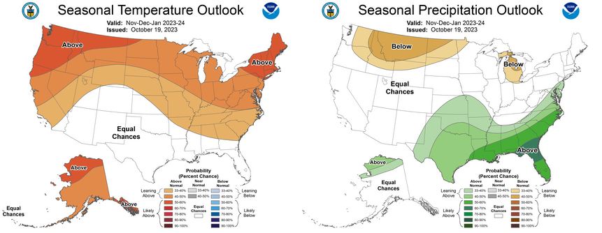
This cool weather period may seem like it is in contrast to the latest seasonal weather outlook driven by El Niño this winter. El Niño winter seasons usually result in warmer than average temperatures and tip the odds toward drier than normal precipitation, and that is what the latest outlook reflects through the winter.
El Niño is when sea surface temperatures in the eastern Pacific tropical waters – those west of Peru – are warmer than average. Those warm sea surface temperatures are now in place and expected to linger through this winter. As a result, the north Pacific storm track driven by the jetstream in the upper atmosphere will tend to spend more time south of the Pacific Northwest, moving through California and the southern tier of the U.S.
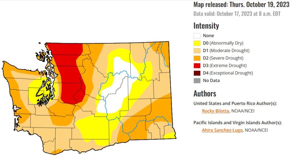
Recent rains have barely made a dent in the drought conditions across Washington. The latest drought monitor shows the state remaining in a dry situation. Seattle Public Utilities continues to ask customers to reduce water consumption.
With El Niño in place for this winter, precipitation will, at best, be average, not offering much relief. And with overall average temperatures being warmer this winter, the average snow level will tend to be higher in the mountains, meaning a good likelihood of a below-average mountain snowpack by next spring. These conditions do not bode well for water supplies heading into next summer and fall.
El Niño also decreases the odds of lowland snow events, intense damaging wind storms, heavy rainfall and flooding. Yet, that does not mean any or all of these impactful storms could not occur, it just reduces the chances.
For instance, it is not uncommon for El Niño winters to have no lowland snow in much of Western Washington. Yet, there have been very snowy years too. Three of the top 10 snowiest winters on record for Seattle were during El Niño winters, including the snowiest winter of them all when 67.5 inches of snow fell at SeaTac Airport during the winter of 1968-69.
After this week’s cool weather, longer-range forecasts point toward a warming and drying trend heading into this weekend and early next week. In fact, it is looking dry for all those trick-or-treaters on Halloween.
In the meantime, this week is going to emphasize that fall weather is really here and provide a sense that winter is not far away.
Follow Ted Buehner, the KIRO FM news meteorologist, on Twitter