Freezing February temps cause lowland snow threat through Thursday
Feb 19, 2018, 6:42 AM | Updated: Feb 20, 2018, 5:37 pm
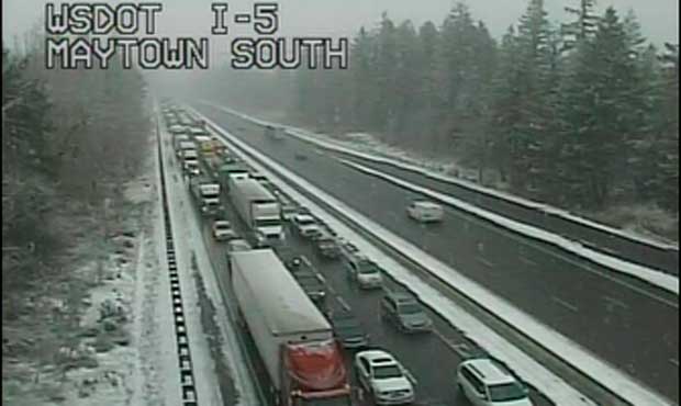
(WSDOT)
(WSDOT)

The National Weather Service has posted a “lowland snow threat” that will last through Thursday in Western Washington.
Parts of Western Washington saw some snow flurries Tuesday. The weather service says that another “weak system” will drop more snow Wednesday night into Thursday morning.
— NWS Seattle (@NWSSeattle) February 21, 2018
Some areas will get up to 3 inches per weather event, according to the weather service, while others will receive less than an inch. In either instance, slippery roads are possible.
Cold Washington weather

(National Weather Service)
The National Weather Service says there was a chance of breaking record low temperatures through the week. Much of Western Washington was colder than some of the Arctic coasts of Alaska on Tuesday morning.
The forecast for Sea-Tac on Tuesday included a low of 25 degrees. The record low for Feb. 20 was set in 1955 at 25 degrees. Olympia could was expected to get as cold as 19 degrees, which is the record low for Feb. 20 set in 2011.
The weather service explains that the “cold trough” that moved into the area over the weekend kept temperatures colder in Washington than in Alaska’s freezing Bering Sea. This is partially because a warm ridge of air (by “Alaskan standards”) moved north of Washington toward Alaska at the same time.
Today’s high of 37 in Seattle was our 5th coldest February high temperature this decade and the coldest February high temp in 4 years. #wawx
— NWS Seattle (@NWSSeattle) February 20, 2018
The cold stretch comes after a series of hot weather records broken last summer.
Snowy forecast
Areas south of Olympia down to Chehalis were expected to see up to three inches of snow by the end of Tuesday afternoon.
Check Western Washington weather
By 4 a.m. Tuesday morning, light snow was already falling around Hoquiam, according to the weather service. A Winter Weather Advisory is in effect for the lowlands of Lewis and Thurston counties, as well as Grays Harbor and southwest Mason County. The heaviest snow is forecast to fall in Lewis County.
The National Weather Service says the Seattle area could receive up to 0.5 inches of snow on Tuesday.